Chicago wakes up under a blanket of clouds and mild air this morning, with temperatures hovering near 64°F and a steady southwest breeze already in play. Highs are expected to climb into the mid-70s, while a 30–40% chance of showers and a few thunderstorms kicks in after 2 p.m. Gusts could reach 25–30 mph into the evening, making it a noticeably blustery day for anyone trying to enjoy time outside. Keep an eye on the radar, because this is just the opening act for a stormy week.
Afternoon Storm Chance
According to the National Weather Service Chicago, the best window for isolated to scattered thunderstorms runs from late afternoon into this evening. Most spots should see light rainfall totals, but any storm that pops could bring a brief heavy downpour. Southwest winds near 15 mph will ramp up with stronger gusts, which could complicate outdoor gatherings and lakefront plans. If storms do develop, localized strong gusts and small hail are on the table.
Tuesday And Wednesday Severe Threat
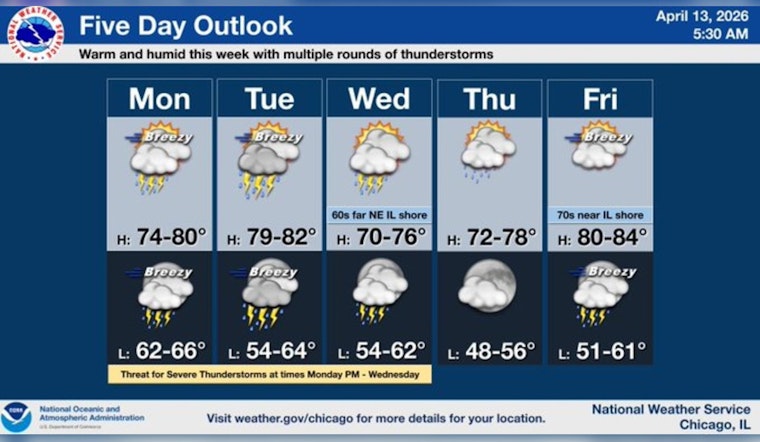
Forecasters point to Tuesday and into Wednesday as the main concern for severe weather, with a more organized storm setup capable of producing damaging winds, very large hail and pockets of locally heavy rain. The Storm Prediction Center has highlighted portions of northern Illinois for an elevated severe risk, and repeated rounds of storms could trigger isolated flash flooding. Anyone with outdoor activities planned from Tuesday afternoon through Wednesday evening should have a backup plan ready and stay tuned for watches and warnings.
Commute And Outdoor Plans
This morning's commute should be mostly dry, if a bit windy, while the afternoon and evening drive could slow wherever heavier cells flare up. Sudden downpours may quickly reduce visibility on expressways and major routes. It is a good idea to secure loose patio furniture, grills, and potted plants ahead of any storm that moves through. Keep phones charged so you can receive local alerts, and be prepared to shift outdoor events indoors if storms approach.
Looking Ahead
Additional rounds of unsettled weather are likely through Friday, with a brief lull possible late Thursday into Friday before another storm system moves in Friday night into Saturday. Behind Saturday's frontal passage, much cooler air spills in for Sunday into early next week, with some inland areas potentially flirting with near-freezing temperatures overnight Sunday. We will continue to update the forecast as the timing becomes clearer.
For background on the warmup and the evolving storm setup, see our earlier piece on the 75-degree sizzler and storm threat. We will post updates if any watches or warnings are issued.


