Chicago woke up in a gray, soggy mood Friday, with fog and light mist hanging over the city. Midway is reporting temperatures around 46°F and reduced visibility, making things murky for early commuters. A few spotty rain showers should linger through the mid-morning rush before tapering off, but most neighborhoods will stay locked under cloud cover. Expect highs in the upper 40s before a lake breeze shoves readings back into the low 40s this afternoon.
Showers Taper as Lake Breeze Knocks Temperatures Down
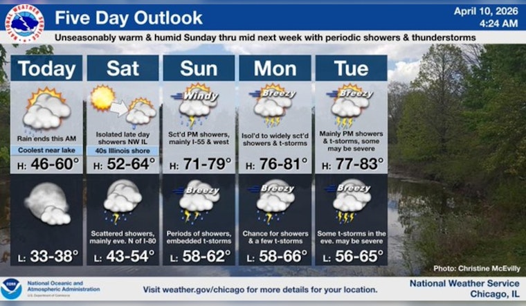
A chance of rain showers is on the board before 10 a.m. Friday, April 10, with overall precipitation odds near 50% and new rainfall amounts of roughly a quarter to a half inch possible. North-northeast winds of 10 to 15 mph will tug cooler air inland and send temperatures sliding through the afternoon. According to the National Weather Service, the rain should end from northwest to southeast and skies should trend drier by this evening.
Weekend Warmup, Then Storm Chances Into Next Week
Saturday looks like the calmer day before a sharp warmup Sunday, when highs may jump near 75°F with south-southwest winds at 15 to 25 mph and gusts up to 35 mph possible. That warm, breezy air will help fuel chances for showers and some thunderstorms late Sunday into Sunday night, with more widespread showers and an elevated risk for stronger storms returning Tuesday and Wednesday. Forecasters with NWS Chicago note the pattern becomes more active next week and a threat for severe thunderstorms exists early in the week.
Commute Tips and Weekend Prep
Dense fog and drizzle will cut visibility on morning roads, so allow extra stopping distance and budget time for a slower commute. Looking ahead to Sunday, tie down lightweight outdoor items and be ready for gusty winds and choppy lakeshore conditions, and boaters should check marine forecasts before heading out. For background on the recent active pattern, see our earlier briefing from last Saturday on gusty winds and a flood watch.


