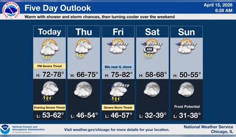
Chicago is waking up cloudy and muggy this morning, sitting around 70°F, with scattered showers already sliding through the area on Wednesday, April 15. Those first waves are just the opener. Expect repeated rounds of showers and thunderstorms through the day, with a high near 74°F and southwest winds of 10 to 15 mph, gusting up to 25 mph. A Flood Watch is in effect through 1:00 AM CDT Thursday, April 16, and forecasters warn that multiple rounds of heavy rain could trigger flash flooding in low-lying and poor-drainage spots.
Rain Timing And Flood Risk
The steadiest batch of showers and thunderstorms is most likely before 4:00 PM today, but the atmosphere is not clocking out at rush hour. Additional rounds are expected tonight, with new rainfall totals of about a half to three quarters of an inch and locally higher amounts in stronger storms. The National Weather Service in Chicago has issued the Flood Watch and notes that repeated storms over the same neighborhoods could lead to rapid runoff and urban flooding. Check the National Weather Service for the latest watches and warnings as the situation evolves.
Severe Threat And Torrential Downpours
A few storms this afternoon and evening could turn strong to severe, with damaging wind gusts the main concern and isolated hail also in the mix. WTTW reports that rainfall rates could spike to a "torrential" 1 to 2 inches per hour in the heaviest cells, which would quickly overwhelm streets and send water into basements in vulnerable spots.
Commute And Local Impacts
When those downpours roll through, visibility can drop fast and standing water may build up on expressways, ramps, and side streets. Plan on slower travel and extra time for both the afternoon and evening commutes. Gusty southwest winds can also make lakefront conditions rough on small boats and send lightweight patio gear tumbling, so it is a good day to secure outdoor furniture, umbrellas, and anything else that might go airborne.
How To Prepare
Basic storm prep will go a long way today. Keep your phone charged and a simple emergency kit in your car, avoid driving through flooded roadways even if the water looks shallow, and move valuables off basement floors if you live in a flood-prone spot. Stay on top of local alerts through your phone and the National Weather Service, and be ready to postpone or move outdoor plans inside if thunderstorms move into your neighborhood.
Looking Ahead
After this soggy Wednesday, there should be a brief lull late Thursday into Friday before the next system arrives Friday night into early Saturday. That one brings another round of showers, more gusty winds, and a drop to much cooler air for Sunday and early next week. For background on the weeklong pattern, see our earlier forecast coverage on the weeklong storm setup and the latest discussion from the National Weather Service Chicago.


