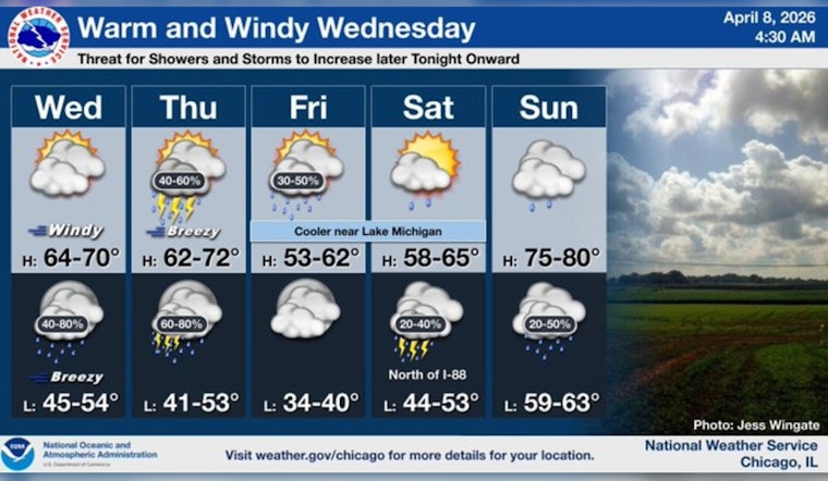
Early Wednesday, Chicago was stuck under mostly cloudy skies and hovering in the upper 30s near Midway. By this afternoon, though, the city is set to trade in the chill for a quick burst of spring warmth, with highs jumping into the mid to upper 60s as a warm sector moves in and southerly winds kick up. Later tonight, a slow-moving front will drag a line of showers and thunderstorms across the region, with heavier bands possible into Friday.
Afternoon Winds Pick Up
Winds will ramp up through the morning and swing southwest by midday, with sustained speeds around 15 to 20 mph and gusts likely topping out near 35 to 40 mph this afternoon, strongest inland and across the north central suburbs. Boat operators and anyone with loose patio furniture may want to lock things down, and high-profile vehicles could feel a bit squirrelly on exposed stretches of road. The National Weather Service notes that Small Craft Advisories are in effect for nearshore waters and that gusty winds combined with heavier overnight rain could lead to a messy commute, according to NWS Chicago.
Showers And Thunderstorms Tonight Into Friday
A line of showers and scattered thunderstorms is expected to roll in late this evening and slowly slide east overnight, with the highest odds between midnight and 4 a.m., followed by additional redevelopment Thursday night and Friday. From tonight through Friday, some spots could see rainfall totals topping an inch, which may push already elevated rivers and creeks a bit higher. A few storms could bring brief heavy downpours and gusty winds, so it is worth keeping an eye on the radar if you have evening plans.
Weekend Outlook
Surface high pressure is forecast to nose in briefly Friday night, setting up a drier, cooler Saturday with highs near the low 50s. After that short break, the pattern looks to turn active again Sunday and into next week. Temperatures may surge back into the 70s, with more rounds of showers and thunderstorms possible Sunday and Monday, a reminder of how spring swings can flip fast. For more background on the setup, see our spring swings flip fast coverage from April 2.
Plan For Your Commute
Plan on giving yourself extra time this afternoon and again overnight, since gusty winds and downpours could slow traffic and cut visibility on busy routes. Avoid driving through standing water, secure outdoor items that might turn into airborne projectiles, and if you are heading to the lakefront, stay off the open water while advisories are in effect.


