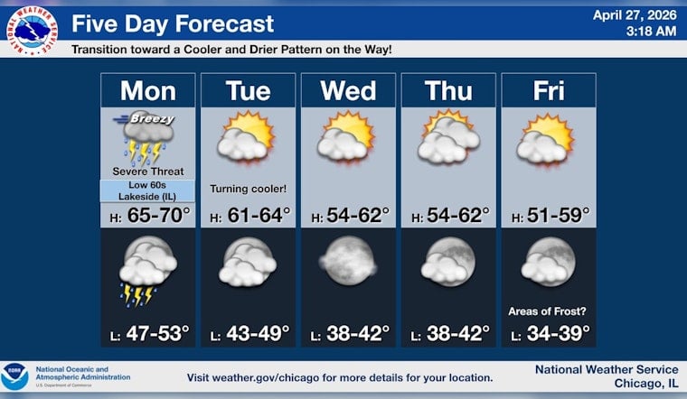
Chicago is waking up to a gray, sticky, wind-whipped Monday, with temps in the mid 50s and a steady south-southeast breeze already flexing over the lakefront. Showers are likely to pop up by late morning and grow more persistent through the afternoon, with highs near 63°F. Gusty winds will turn umbrellas into a contact sport, and pockets of heavier rain could trigger brief street flooding and slow the afternoon commute. Keep evening plans loose; the weather is expected to get rowdier after dark.
What To Expect Monday, April 27, 2026
South-southeast winds around 15 mph, with gusts up to 40 mph, are on tap this afternoon, and forecasters put the chance of showers and thunderstorms in the 70 to 80 percent range for Monday, April 27, 2026. New rainfall totals of roughly a quarter to a half inch are possible, with locally higher amounts in stronger storms. The National Weather Service has also flagged a small window, mainly north of the interstate, between about noon and 3 p.m., while the primary severe threat, featuring damaging winds and hail, is expected later, roughly between 4 and 11 p.m. According to the National Weather Service Chicago office, boaters should pay close attention to Small Craft Advisories on the nearshore waters through Tuesday morning.
Evening Severe Threat
The main concern tonight is a more organized line of storms capable of producing damaging straight-line winds and hail that could tangle the evening commute and disrupt outdoor events. Tornado risk for the immediate city remains limited, but forecasters note that the exact placement of a warm front will be key in deciding whether a narrower band of higher tornado risk develops to the south or southeast. If you are headed to concerts, games or other outdoor gatherings, have a quick exit plan, keep your phone charged and move indoors at the first flash of lightning or sudden burst of heavy rain. Brief power flickers and downed tree limbs are on the table in the stronger storm cores.
Commute And Where To Find Updates
Plan on slower going this afternoon and evening; standing water, gusty crosswinds and lightning can quickly turn routine trips into slog territory for drivers, cyclists and transit riders. We ran a preview of this system in our lakefront fog and storm smackdown preview, and today’s forecast sharpens the timing and underlines the wind risk. Check real-time alerts from the National Weather Service and sign up for service notices from local transit agencies before heading out. If you encounter flooded streets, turn around, do not drown, and secure loose outdoor items until the storms move on.


