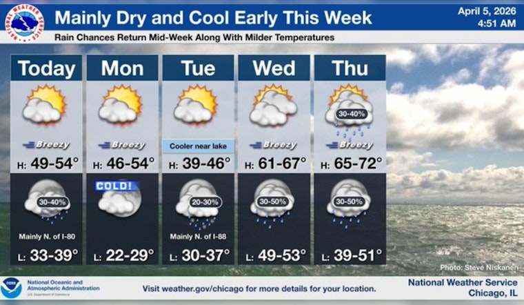
Chicago woke up on Sunday, April 5, 2026, under mostly cloudy skies and a brisk west-northwest wind cutting through the 39°F reading at Midway. It feels colder than the numbers suggest, and while the city is expected to climb into the low 50s this afternoon, the breeze will keep things feeling on the raw side, especially near the lake. If you are heading out, plan on a noticeably blustery day.
Afternoon Winds, Lakefront Impacts
Winds will hold from the WNW around 10–20 mph through the afternoon, with gusts pushing up to about 30 mph, particularly along the lakefront and over exposed bridges. A Small Craft Advisory remains in effect for Illinois and Indiana nearshore waters through 10 a.m. Sunday, so smaller boats are better off staying in port or close to shelter. For the latest marine and lake forecasts, check the NWS Chicago.
Tonight: Spotty Showers Possible
A weak front swinging through late Sunday night could squeeze out a few scattered showers, mainly between 11 p.m. Sunday, April 5, and 4 a.m. Monday, April 6. Most neighborhoods will stay dry, but a brief shower cannot be ruled out. Overnight lows will dip to around 38°F, with lake-adjacent areas running a couple of degrees milder as winds ease for a time. The chance of measurable rain sits at a modest 30%, so evening plans should be fine, though keeping an umbrella handy is not a bad idea if you are out late.
Early Week Cool Down
Temperatures will slip early in the week. Monday should top out near 48°F with a persistent, blustery northwest breeze. Monday night into early Tuesday morning could bring lows near 28°F away from the lake, cold enough for a solid late-season chill. Tuesday will run noticeably cooler with a high near 37°F, and forecasters note a slight chance of a brief rain/snow mix Tuesday night if the system trends a bit colder. By midweek, conditions start to moderate, with highs rebounding into the 60s by Wednesday and increasing chances for showers and storms later in the week.
What This Updates
This forecast updates Hoodline’s April 4 briefing with fresh timing on the advisory, a more detailed wind forecast and the modest overnight shower chance. For more context on the weekend’s soggy setup, see our earlier coverage of the city’s gusty winds and flood watch.


