Memphis is starting the day in a gray mood, with rain and fog draped over the city, visibility reduced in spots, and temperatures sitting near 52F at Memphis International Airport. Showers and embedded thunderstorms are expected to hang around through Wednesday, with a high near 65F and a steady north-northeast breeze. Drivers should budget extra time for a slower, splashier commute on wet roads.
Afternoon Rain And Thunder
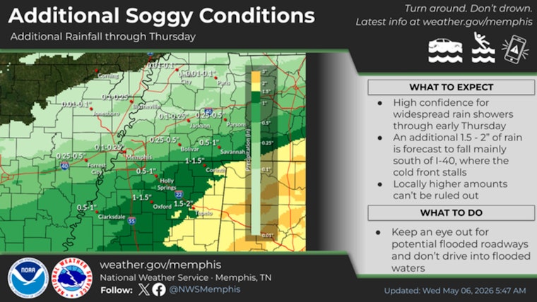
The wet weather is not a brief cameo. Showers and thunderstorms are expected to continue through the afternoon and evening, with about a 90% chance of precipitation and new rainfall totals of roughly three-quarters to one inch possible in the heavier cells, according to the National Weather Service in Memphis. Most of the action should wind down after 11 p.m., with lows sliding into the low 50s overnight. If you are headed out later, keeping an umbrella close is still a smart move.
Flash Flood And Severe Threats
Forecasters are also watching for training storms, which could repeatedly pass over the same areas and lead to locally heavy rainfall totals and urban flash flooding. Broader outlooks note the potential for damaging winds across parts of the Mid-South. The Weather Prediction Center flags an area of excessive rainfall potential that could cause ponding on roadways and push storm drains in low-lying neighborhoods to their limits. While the greatest risk for severe weather is generally south of I-40, isolated damaging wind gusts and a brief tornado are not completely off the table for parts of the region.
Commute And Event Impacts
Between fog and occasional heavy downpours, travel is likely to slow both this morning and during the evening rush. Drivers should be ready for standing water on some surface streets and bridges. Air travelers and transit riders are not immune either, as flights at Memphis International and MATA bus service could experience delays, so checking with airlines and operators before leaving home is wise. Outdoor plans will fare better indoors today, or at least with a solid rain backup in place.
Late Week Outlook
By Thursday and Friday, high pressure is expected to build in, bringing cooler, drier air and afternoon highs in the upper 60s to mid 70s. A warming trend looks to return over the weekend. Another front may drag rain back into the forecast by Sunday into early next week, so it is worth keeping an eye on updated outlooks. For any watches, warnings, or advisories, follow local forecasts and official guidance.


