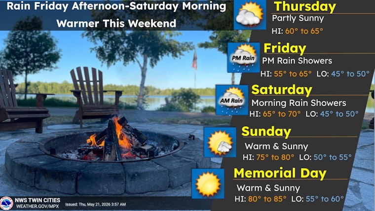
Minneapolis woke up on the chilly side this morning, with readings in the mid 40s at the airport, but the city is on track to warm into the mid 60s by afternoon under a mix of sun and clouds. East southeast breezes will strengthen as the day goes on, and the next real weather shakeup arrives Friday evening when showers move in.
Afternoon Winds And Temperatures
Highs should top out near 66°F today with east southeast winds around 5 to 10 mph and gusts into the upper teens, so the afternoon commute could feel a bit on the breezy side. Skies turn mostly cloudy overnight with a low near 47°F, according to the National Weather Service.
Friday Night Into Saturday
A weak system is expected to push showers into the area Friday evening, with the best bet for steadier rain after dark and lingering showers into Saturday morning. Forecasters say western Minnesota could pick up roughly 0.5 to 1.0 inches of rain Friday night, with totals dropping to a few tenths of an inch farther east, so plan on wet roads and slower travel for the Friday evening drive, per the NWS forecast discussion.
Memorial Day Warm-Up
Clouds should break and skies clear by Saturday afternoon, and temperatures will climb through the holiday weekend. Highs are expected to reach around 71°F on Saturday, near 80°F on Sunday, and a summertime 87°F on Memorial Day Monday. Guidance keeps readings well above normal through next week, so most outdoor holiday plans look dry and noticeably warmer, according to the National Weather Service.
Plan Ahead
There are no watches or warnings in effect from the Twin Cities office right now, but travelers should check for updates before heading out Friday evening and build in some extra time on the roads. Rain gear will be the smart move for the Friday night commute, while sunscreen will be the must-pack item for the holiday weekend. Coverage will be updated if any stronger storms or advisories develop, per the NWS forecast discussion.


