

























































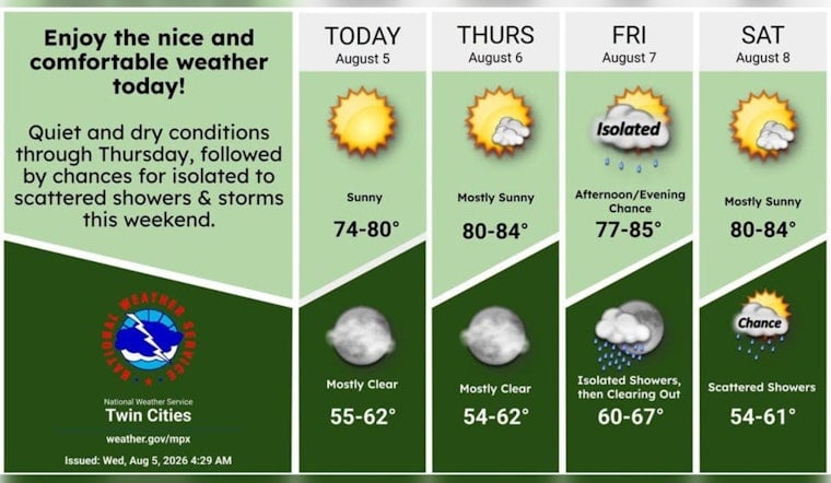
Minneapolis is waking up to clear skies and temperatures in the low 60s Wednesday, with a sunny afternoon ahead and a high near 80 degrees. Winds will stay light from the west, making for an easy day to walk, bike or linger outside. The quiet stretch holds through Thursday before shower and thunderstorm chances return Friday.
Sunny Stretch Through Thursday
Wednesday will remain dry and bright, with west winds ranging from calm to around 10 mph and afternoon temperatures reaching about 80 degrees. Skies stay mostly clear Wednesday night as temperatures fall to around 62. According to the National Weather Service Twin Cities, Thursday turns warmer, with sunshine, a high near 84 and south-southwest winds of 5 to 15 mph.
Friday Brings The First Storm Chances
Friday starts mostly sunny and warm, but a 40% chance of rain showers arrives between about 7 a.m. and 1 p.m. Shower and thunderstorm chances increase from early afternoon through the evening as a front moves across the region. Severe weather is not currently expected, although the best chance for storms is forecast across southeastern Minnesota and western Wisconsin Friday evening.
Warm Weekend With Scattered Showers
Saturday looks sunny and warm, with a high near 84 and only a small chance of rain. Sunday could reach 85 degrees after a slight early chance of showers or thunderstorms, while another 40% chance of evening storms arrives Sunday night. Monday brings a chance of morning showers and thunderstorms with a high near 81, followed by mostly sunny skies and a high near 80 Tuesday.
For Minneapolis, the forecast favors plenty of dry time for weekend plans, but Friday evening through Monday is the stretch to keep an eye on the sky. There are no active watches or warnings listed for the local forecast area.





