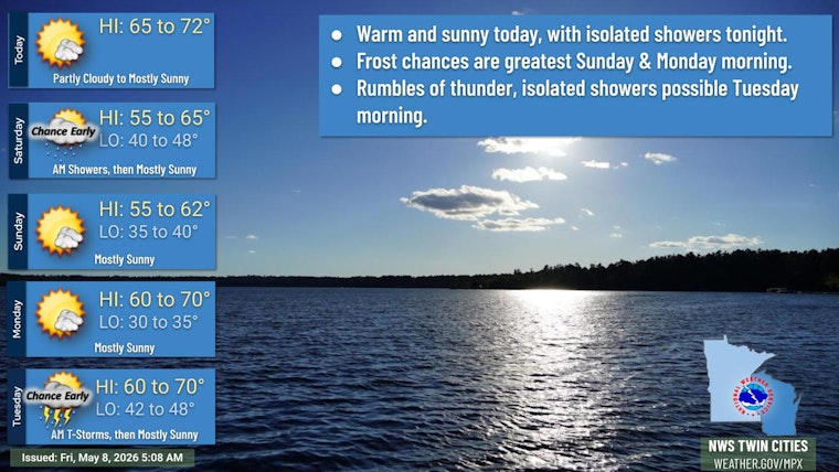
Minneapolis rolled into Friday, May 8, 2026, under clear skies and a cool 45°F, but the chill will not stick around for long. Temperatures are expected to jump to around 72°F under mostly sunny skies this afternoon, with a brisk west-southwest breeze making it feel a bit livelier outside. A cold front sliding in late tonight should bring a small chance of pre-dawn showers and set the stage for a cooler, more springlike weekend at night.
Afternoon Warmup And Wind
By mid to late afternoon, highs should top out near 72°F, paired with a west-southwest wind of 5 to 15 mph and gusts that could reach into the 20s in exposed spots and across the western suburbs. It will be a pleasant day overall, but the breeze may turn lightweight patio furniture, umbrellas, and trash bins into slow-moving projectiles if they are not secured. The National Weather Service Twin Cities notes that stronger mixing this afternoon could briefly boost gusts a bit higher in a few locations.
Tonight Into Saturday
Late tonight into early Saturday, a cold front will move through the region and bring a 20 to 30 percent chance of spotty rain showers after about 3 a.m., mainly for areas north of the I-94 corridor. Saturday itself looks cooler, with a high near 64°F and only isolated showers lingering into the morning. After that, most of the day should be dry. If you are out early, plan on a light jacket and keep an eye out for patches of damp pavement on the morning drive or walk.
Frost Risk This Weekend
As skies clear and winds ease Saturday and Sunday nights, temperatures are expected to dip into the upper 30s to low 40s, which is cool enough for pockets of frost to form in low-lying or sheltered areas. Gardeners who rushed their tender transplants into the ground will want to cover them Friday night and again Sunday night if they can. The chilly nights should be short-lived, with a more sustained warmup lining up for early next week.
Burning Restrictions
The Minnesota Department of Natural Resources has expanded its spring burning restrictions to include Hennepin County, so residents are being asked to hold off on open brush or debris burns for now. During the restriction period, burn permits can be suspended, and violations may come with fines or other penalties. For the latest county restriction map and daily status updates, check the Minnesota DNR.
Looking Ahead
Forecasters expect a stronger warmup to kick in early next week, with highs rebounding into the mid to upper 60s and a better shot at widespread showers and thunderstorms from Monday night into Tuesday. That early-week system is currently the leading candidate to deliver measurable rain to much of the region, so those with outdoor plans around Mother's Day weekend may want to keep tabs on the timing. By midweek, a ridge is expected to build in, which should nudge highs back into the 70s by Wednesday and Thursday.
What To Do
Today offers a solid window for errands, walks, or yard work before the cooler nights return, but it is worth securing lightweight items outdoors and dressing in layers for the breezy afternoon. Hold off on backyard burning until restrictions are lifted, and always check the DNR site before planning any burns. For the latest forecast tweaks, rain timing, and any updated wind concerns, keep an eye on forecasts from the National Weather Service before heading out.


