Minneapolis rolled into Wednesday, May 20, on the chilly side, with clear skies and temperatures near 39°F at Minneapolis–Saint Paul International Airport. Light to calm winds and very dry air made low-lying spots vulnerable to a quick hit of frost before sunrise, so it is worth giving potted plants and fresh transplants a once-over this morning. The day will warm quickly, so expect to peel off a layer by around midday as temperatures climb.
Sunny Afternoon, Light Winds
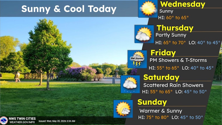
Sunshine is expected to stick around through the afternoon, with a high near 64°F and a gentle north breeze around 0 to 5 mph. Parts of the region sit under a Frost Advisory through 8 a.m. CDT, mainly aimed at rural areas and outlying suburbs rather than downtown Minneapolis, according to the National Weather Service Twin Cities.
Weekend Outlook And Holiday Warmup
The next shot at showers and thunderstorms arrives from Friday afternoon into Saturday, with the most active period expected Friday night. Forecasters say western Minnesota could pick up roughly 0.5 to 1.0 inches of rain Friday night, with amounts dropping to a few tenths of an inch farther east. There is also a substantial chance of thunderstorms on Friday night that could briefly affect travel. A warmer, sunnier stretch is on tap for the Memorial Day weekend, with highs near 78°F Sunday, climbing into the mid 80s Monday and near 88°F Tuesday, according to the National Weather Service Twin Cities.
What To Do
Bring vulnerable potted plants inside or cover garden beds before dawn, and keep a light jacket nearby for early commutes. If you have plans on Friday evening, keep an eye on the forecast, since storms then could disrupt travel or outdoor events. Updates will follow if any watches or warnings are issued.


