Nashville is waking up under a gray, drippy sky this morning (Wednesday, May 6), with light rain falling, temperatures near 55°F, and plenty of humidity to go around. Showers and thunderstorms are expected to hang around through the day and into the evening, with a high near 67°F and north-northwest winds around 5 mph. The soggy setup could bring pockets of heavier rain that slow commutes and leave standing water in low-lying spots.
What To Expect Today
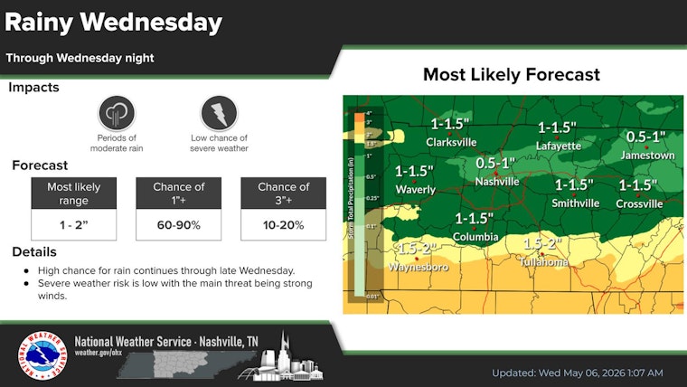
Showers and thunderstorms are most likely through Wednesday, with an overall rain chance around 70-80 percent. Typical daytime rainfall totals are expected to land between a half inch and three quarters of an inch, although isolated heavier amounts are possible in stronger storms. According to the National Weather Service, showers and storms should be most numerous through the morning and then again this afternoon and evening. The main issues will be brief heavy downpours and gusty winds. Keep that umbrella close and be ready for quick drops in visibility when heavier cells roll through.
Commutes And Outdoor Plans
Roads will stay wet and slick, and evening drives could be slower than usual as rain lingers and ponding develops on underpasses and neighborhood streets. Plan for extra travel time and ease off the gas when the rain picks up. Metro Nashville Emergency Management advises residents to sign up for local alerts, avoid driving through standing water, and treat any flooded road as impassable. If you have outdoor plans tonight, you may want a backup: move things indoors or consider rescheduling until the drier weather that arrives Thursday.
Looking Ahead
Drier, cooler air is expected to slide in on Thursday, with highs in the upper 60s and a much more comfortable feel. A stronger warm-up follows Friday into the weekend, with highs climbing into the mid-70s and low 80s by Saturday. Another round of showers and thunderstorms is possible on Sunday, with higher rain chances in the afternoon, so keep an eye on updates if you have outdoor plans late in the weekend. Forecasters note that the overall severe threat stays on the low side, but localized heavy rain is still on the table. Check in with the National Weather Service for timing details and any changes to the forecast.
Quick Tips
Grab a compact umbrella, leave a little earlier than usual for commutes, and steer around standing water on the roads. Check radar or local alerts before heading out, since showers and storms will be hit-or-miss and conditions can change quickly.


