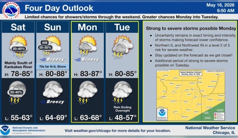
Chicago is rolling into the weekend on the sticky side, waking up Saturday to muggy air, low 60s and mostly cloudy skies. A south-southwest breeze will nudge temperatures into the lower 80s this afternoon, with scattered storms possible in the morning and a lower chance later in the day. Most neighborhoods that see rain will only get brief, light showers, although a few heavier downpours or gusty winds could pop up. A light jacket or umbrella is still a smart move for early plans.
This Morning And Afternoon
Showers and thunderstorms are possible before 9 a.m., then only a slight chance lingers through the afternoon as skies turn partly sunny. Highs should land near 81 degrees, with south-southwest winds around 10 mph and gusts up to 20 mph. Closer to the lake, temperatures may run cooler. New rainfall amounts should be light, generally under a tenth of an inch where storms do develop, according to the National Weather Service.
Tonight And Sunday
A mid-level disturbance could fire up more showers and isolated thunderstorms tonight, with the highest chances north of I‑80 and lows near 61. Sunday looks warmer, with highs in the low 80s and southeast winds around 5 to 20 mph, plus gusts that could reach 30 mph in the afternoon. Clouds will mix with sunshine and most spots should stay dry outside of any morning showers and the afternoon breeze. Those breezy conditions Sunday night will help keep lows in the mid- to upper-60s.
Monday And Tuesday Outlook
Thunderstorm coverage is expected to ramp up Monday and Tuesday as a frontal system teams up with Gulf moisture. Monday's high could push into the mid-80s, along with an elevated chance of widespread showers and storms. Some of next week's storms could be strong to severe, with damaging wind and heavy rainfall as the main concerns. By midweek, cooler and drier air should filter in, dropping highs back to the low 60s by Wednesday. The Storm Prediction Center currently highlights increased severe weather probabilities for portions of the Upper Midwest.
What To Expect
If you can, front-load outdoor plans this weekend, and have indoor backups on deck for Monday and Tuesday. Secure lightweight outdoor items so they do not get tossed around by gusty winds, and be ready for brief travel delays in heavier downpours or during stronger storms. Local officials and transit providers may roll out short-notice advisories if storms organize, so keep an eye on official alerts and build in a little extra time on the roads. For the latest watches and warnings, check in with your local National Weather Service office before heading out.


