

























































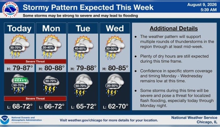
Chicago is waking up to muggy air and temperatures near 66 degrees Sunday morning, but the calm start will not last. Showers and thunderstorms are likely after noon, with the possibility of strong storms, damaging winds, hail and flash flooding later in the day and overnight.
Temperatures will rise to near 82 degrees before falling into the upper 70s as storms move through. The National Weather Service Chicago office says south winds will generally run 5 to 10 mph, with gusts up to 20 mph.
Storms Arrive After Noon
Morning skies should remain mostly sunny to partly sunny, with the rain chance increasing around midday. Storm coverage could become more likely between roughly 2 p.m. and 5 p.m., when the chance of precipitation rises to 60% or higher.
Any stronger storms could produce damaging wind gusts and hail around an inch in diameter. Forecasters also say a tornado cannot be ruled out if a rotating storm develops near a boundary later Sunday.
Heavy Rain Threat Builds Sunday Night
A second round of showers and thunderstorms is expected from late Sunday afternoon through Sunday night, when the low will fall only to about 72 degrees. Rainfall totals could reach a quarter to a half-inch during the day, with another 1 to 2 inches possible overnight.
That setup could bring locally intense downpours and flash flooding, especially if storms repeatedly pass over the same neighborhoods. Anyone heading out should have an indoor backup plan and avoid driving through water-covered streets.
More Storms Before A Cooler Thursday
Monday will stay warm near 80 degrees with a 40% chance of showers and thunderstorms during the day, followed by a higher storm chance Monday night. Showers and thunderstorms are likely again Tuesday, while Wednesday brings another chance of storms and a high near 81.
Conditions should ease somewhat Thursday, with partly sunny skies and a high near 76 degrees. The outlook remains unsettled into Friday and Saturday, when additional shower and thunderstorm chances return.





