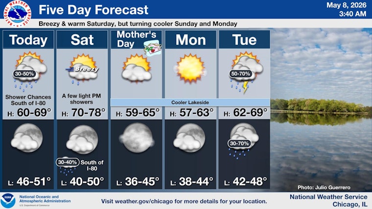
Chicago wakes up cool but mostly clear Friday morning (May 8, 2026), with temps near 45°F at area observation sites as of 5:35 a.m. The day shapes up mild, with afternoon highs around 61°F and a light southeast breeze at 5–10 mph.
Afternoon Shower Chances
Skies stay partly to mostly sunny through the afternoon, with the best shot at isolated, high-based showers lining up south of the city near the Kankakee River. Downtown and the lakefront are favored to stay dry, though a stray sprinkle along a slow-moving lake-breeze boundary is still on the table. Airport operations should hold VFR for most of the day, according to the latest from the National Weather Service Chicago.
Saturday Warm-Up And Gusty Winds
Saturday delivers the warmest stretch of the forecast, with highs near 73°F and west winds at 10–15 mph, gusting up to about 25 mph in the afternoon. A slight chance of late-day showers shows up mainly across the southern suburbs, but any rainfall amounts look light. For background on how this wind setup plays out, check our earlier coverage: Windy City Whiplash.
Sunday Into Next Week
Cooler, drier air settles in Sunday, trimming highs back to around 56°F and sending overnight lows into the mid-40s. Rain and thunderstorms become more likely on Tuesday, May 12, with showers expected during the day and into the evening, so it is smart to line up indoor backup plans for any outdoor events.
What To Expect For Commuters
Friday’s commute looks mostly smooth sailing, with dry roads, light winds, and decent visibility. Saturday’s gusts could make the lakefront feel extra blustery and may nudge around unsecured outdoor furniture. By Tuesday, the wetter setup could slow the evening drive, so commuters may want to head out a bit earlier and factor in extra travel time.


