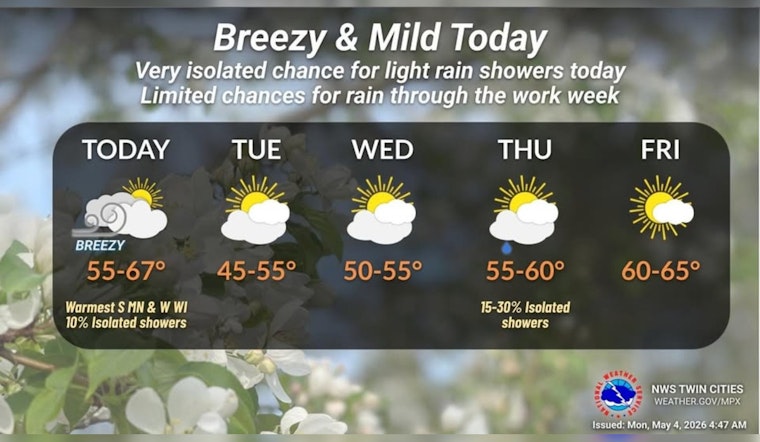
Minneapolis woke up to clear skies and a mild start on Monday, May 4, 2026, with temperatures hovering near 59°F at Minneapolis–St. Paul International Airport. The calm will not last long. A strong cold front is set to sweep through during the morning, nudging highs to about 64°F this afternoon before readings slip into the low 50s by evening. Gusty northwest winds will be the headline act, with peak gusts expected around 30 to 35 mph that could easily rattle lightweight outdoor items.
Afternoon Winds Pick Up
As the front passes, winds will swing from the southwest to the northwest, and they will not be shy about it. Forecasters expect sustained west winds of 10 to 20 mph, with gusts up to 35 mph possible in the afternoon. The National Weather Service Twin Cities is flagging a brief window of stronger winds that could make driving a bit awkward on exposed stretches, particularly for high-profile vehicles. On the bright side, rain chances stay low, under 20 percent, so most neighborhoods should stay dry aside from a stray shower.
Cooler Midweek With Frost Risk
Behind the front, spring takes a cool detour on Tuesday, May 5, 2026, and Wednesday, May 6, 2026. Highs on Tuesday should top out near 54°F, with overnight lows sliding into the mid-30s. Tuesday night currently looks like the coldest stretch, which brings a real risk of frost and a brief dip below freezing for low-lying and outlying areas. That means gardeners will want to cover tender plants and potted favorites before dusk. For planting and protection tips, check out our earlier frosty wake-up forecast.
What To Watch And Do
If you have a backyard setup that looks even remotely portable, now is the time to secure it. Tie down patio furniture and lightweight trash bins this morning and through the afternoon, since gusts near 30 to 35 mph can topple umbrellas and send loose items skittering down the block. Commuters should see only minor impacts beyond a few gusty stretches, although drivers of high-profile vehicles may really feel it on bridges and open roadways. If you have afternoon travel booked, consider checking in with your carrier. For ongoing updates and the full forecast, keep an eye on the National Weather Service Twin Cities.


