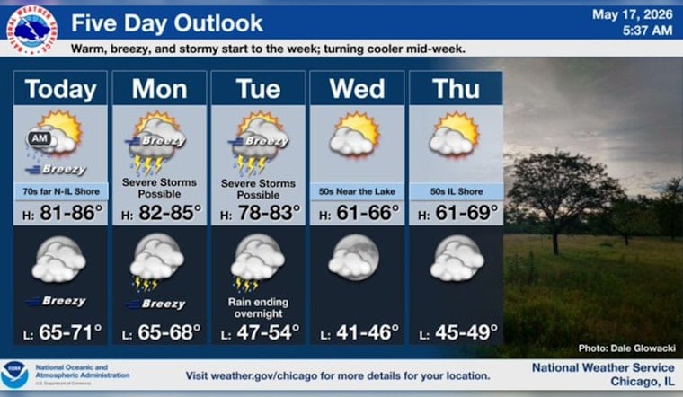
Chicago woke up to a muggy, mild start in the mid 60s, and that warm, sticky air is sticking around. The morning stays mostly dry with only a slight chance for spotty showers through late morning, but the real headline today is the breeze. A summerlike afternoon near 84°F is on tap, with steady south-southeast winds gusting around 25 to 30 mph. Expect a choppy Lake Michigan and be prepared for loose lawn chairs, trash bins, and other unsecured gear to get pushed around by the stronger gusts.
Afternoon Winds Crank Up Over City And Lake
This afternoon, south-southeast winds of 10 to 20 mph with gusts up to 30 mph are likely, and a bit higher in spots if deeper mixing kicks in. The lake will turn rough, with a Small Craft Advisory in effect from 1 p.m. to 10 p.m. from Wilmette Harbor, IL, to Michigan City, IN. According to the National Weather Service Chicago, boaters and beachgoers should play it cautious this afternoon.
Monday–Tuesday Storm Threat
A frontal boundary moves in Monday and hangs around into Tuesday, bringing rounds of showers and thunderstorms along with the chance for some stronger storms. A few of those could pack damaging wind gusts and hail. The Storm Prediction Center highlights an elevated severe-risk corridor across parts of the Plains and Upper Midwest and notes that scattered severe storms could clip our area. If you have outdoor plans Monday or Tuesday, keep them flexible and stay alert for any watches or warnings.
For today, count on gusty winds that make umbrellas more trouble than they are worth and that tug at tents, canopies, and lightweight patio setups. Secure grills, furniture, and anything that can tumble before the afternoon winds really get going. Behind the front, temperatures drop sharply by midweek, with highs only in the mid 50s by Wednesday as drier, sunnier weather settles in for a brief midweek reset.


