Wednesday, June 24, Austin woke to mostly cloudy, muggy air parked in the upper 70s, offering almost no morning break from the heat. Clouds should thin by mid-morning, letting the sun punch through and drive highs into the mid to upper 90s, with many spots feeling like the low 100s once the humidity piles on.
Afternoon Heat And Gusts
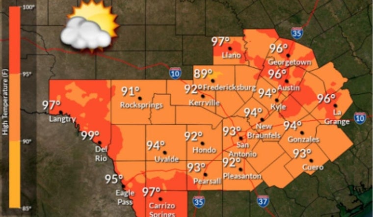
Today’s high should land near 97°F, with heat index values topping out around 101°F. South winds will run about 5 to 10 mph, with occasional gusts near 20 mph, so expect a light but noticeable breeze rather than true relief. Overnight, temperatures only slip into the mid-70s, which means the city stays warm and sticky well after sunset.
Forecasters at the National Weather Service say the area stays dry with no watches or warnings on the board for now.
Rest Of The Week
A stubborn subtropical ridge keeps Central Texas locked into a dry pattern through the weekend. Highs will hover in the mid to upper 90s, with a few afternoons flirting with 100°F and plenty of “feels like” readings pushing into triple digits.
Afternoons turn a bit breezier later in the week, with gusts into the mid-20s on Thursday and isolated gusts in the 30 to 35 mph range possible Saturday night. It will feel blustery at times, but not enough to chase off the heat.
Heat Safety And Cooling Centers
If you are heading outside this afternoon, plan for it: drink plenty of water, take frequent breaks and try to avoid intense activity during the peak heat of the day. The City of Austin is offering cooling options at select parks and library locations during normal business hours; you can find local cooling centers through the City of Austin. Check on older neighbors and make sure pets have shade and water, since those mid-70s lows overnight mean limited relief after dark.
Compared with last week’s more extreme spikes, this stretch is a bit milder, but many neighborhoods will still see frequent triple-digit feels through early next week. We will post updates if any heat advisories or other watches are issued.


