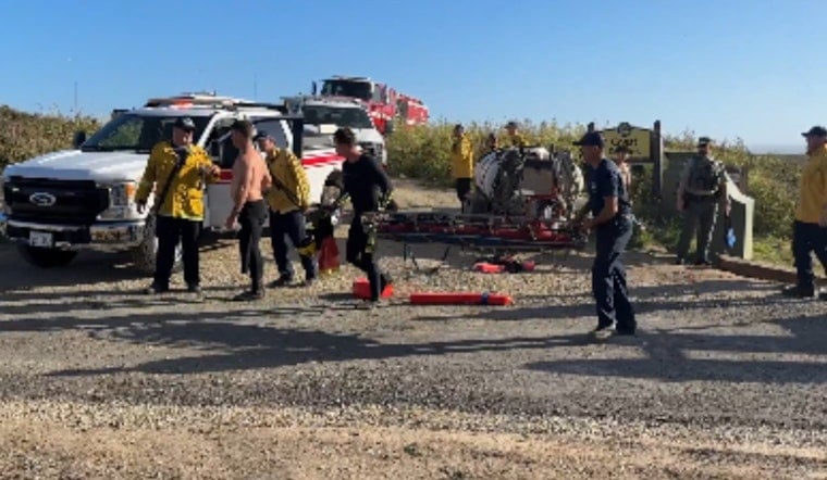
Rescue crews rushed to a remote stretch of the Santa Cruz coast today, pulling a person from rising surf near Bonny Doon in foggy, cool morning conditions. Officials said it was the fifth ocean rescue in roughly a month along about a one-mile run of shoreline from Yellow Bank Beach to Bonny Doon Beach, a pretty but punishing slice of coast where things can go wrong fast.
In a post on X, CAL FIRE CZU said the response brought in Alma Helitack Copter 614, California State Lifeguard rescue swimmers, Santa Cruz city rescue swimmers, Central Fire and Santa Cruz Fire, along with county and sheriff units. Rescue swimmers fought heavy surf as they escorted the person to safety along the tight stretch between Yellow Bank Beach and Bonny Doon Beach, an area the agency noted has seen five rescues in roughly a month.
OCEAN RESCUE: This is the fifth rescue we’ve performed in a month along a 1-mile stretch of coastline, from Yellow Bank Beach to Bonny Doon Beach.
— CAL FIRE CZU (@CALFIRECZU) June 11, 2026
Santa Cruz County Volunteer Fire Captain Kyle Breton explains what happened, and the dangers of being caught on the beach when the… pic.twitter.com/b4nUltPWzs
Kyle Breton, a Santa Cruz County volunteer fire captain, explained that narrow pocket beaches along this coastline can quickly turn hazardous when the tide comes in. People who linger too long can find themselves squeezed between steep cliffs and rising water. Breton urged anyone who gets trapped to move to high ground and call 911 instead of gambling on risky climbs or swims. The attached transcript from the call also listed a morning temperature of 67°F and an air quality index of 44 at 7:00, and noted that an after-action briefing from the incident set off another emergency inside Santa Cruz city limits that required city agencies to respond.
Why this stretch is seeing repeated calls
The northern Santa Cruz shoreline in this area is rugged and unforgiving. Steep bluffs, sea caves and narrow pocket beaches can make for dramatic photos, but they can also turn safe conditions into a bad situation within minutes as tides and swell shift. Last Saturday, a man died in a cliff fall at Bonny Doon Beach and his body was recovered using a rope system, according to the San Francisco Chronicle. Less than a month before that, eight people were rescued after a rising tide trapped them near a sea cave off Davenport, in what was reported as a tide-trap drama. Together, those incidents underscore how quickly conditions can deteriorate on a stretch of Highway 1 coastline that looks calm and scenic at low tide.
Check the tide chart before you go
Local officials and visitor guides repeatedly stress the same basic rule for this coast: check tide charts and posted warnings before hiking down bluffs or stepping into caves. Wind and swell can shove water deep into spots that seem harmless when the tide is low. NOAA provides tide predictions for Santa Cruz, including times and heights for high and low tides, and Visit Santa Cruz County emphasizes planning visits around low tide and staying above posted signs so you do not get cut off. If you see someone in immediate danger, call 911 and try to alert a lifeguard if one is on duty.
This latest rescue highlights the steady demand on lifeguards and fire crews along this narrow slice of coast and the importance of multi-agency coordination in difficult surf and cliff operations. Officials are again urging visitors to stay above the high-tide line, obey posted warnings and give cliffs, caves and moving water plenty of space.


