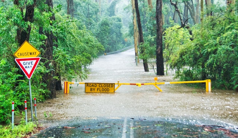
Central Boone County woke up to a soggy surprise Monday morning as a fast-hitting round of thunderstorms dumped several inches of rain, triggering a flood warning and turning familiar routes into no-go zones. Water pushed into low-lying streets, small streams and underpasses, with Columbia and nearby towns seeing pooling in neighborhoods and at low crossings. Officials also warned that state parks and recreation sites in the storm’s path could see rising water, and drivers were urged to watch for trouble spots along Interstate 70 where standing water can hide deeper flows and swept-up debris.
According to the National Weather Service, Doppler radar showed storms producing roughly 2 to 4 inches of rain across the warned area, with flash flooding occurring or imminent. The warning window was listed as starting about 9:00 a.m. CDT, with mid-morning flagged as the period of greatest concern.
Where The Flooding Was Focused
As reported by ABC17, the NWS highlighted Columbia, Columbia Regional Airport, Rocheport, Midway, Easley, Murry, Harrisburg and McBaine as communities already dealing with high water. Rock Bridge State Park, Finger Lakes State Park and the Jewell Cemetery Historic Site were also swept into the warning area, putting popular outdoor spots on notice for rising creeks and soggy trails.
The alert called out Interstate 70 between exits 115 and 133 as a problem stretch where motorists could encounter flooded underpasses and pooled water. Local crews and drivers were told to expect localized road closures and to steer clear of any lane that looks more like a pond than pavement.
Rivers And Creeks To Watch
Separately, the NWS river forecast product put Hinkson Creek at Columbia on its watch list, with a projected crest near 15.6 feet. That is just under the Providence Road bridge flood threshold of 16.0 feet but still high enough to threaten low-lying banks and nearby streets. At 6:00 a.m. CDT, the observed stage was around 13.8 feet, and forecasters warned that additional runoff could nudge levels higher if heavier rainfall persisted.
National Weather Service river statements said officials would keep monitoring river stages and issue follow-up statements as conditions evolved.
Safety And Travel Advice
Local reports echoed the familiar NWS admonition, "Turn around, don't drown," noting that most flood deaths happen in vehicles and urging motorists not to test their luck at flooded crossings, ABC17 reported. Travelers were urged to check the Missouri Department of Transportation’s traveler map for real-time closures and incidents before heading out at MoDOT's traveler map.
Emergency officials recommended staying off low-lying roads and underpasses until waters recede. When in doubt, pick a higher route and reach out to local authorities for the latest updates.
Forecasts pointed to improving weather and falling water levels later in the day, but officials cautioned that follow-up products could still be issued if additional heavy cells bubble up. Residents near streams and other low spots were advised to keep an eye on official channels and avoid unnecessary travel until conditions clearly improve.


