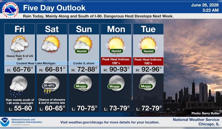
This morning, Friday, June 26, Chicago wakes up under mostly cloudy skies and a cool start, with temperatures in the mid 60s. Northeast winds around 10 mph, gusting near 20 mph, are keeping the lakefront noticeably cooler than many inland neighborhoods.
Showers Stay South, Most Of The City Stays Dry
Rain chances are focused well south of the city today and tonight, with scattered showers and the best shot at heavier downpours staying south of I-80 and especially near and south of U.S. 24. That setup leaves downtown and the lakefront mostly cloudy but likely dry, while southern suburbs could be dealing with soggy drive times. According to the National Weather Service in Chicago, pockets of heavy rain are possible this afternoon and evening well south of the metro area.
Afternoon Winds And Commute
Through the afternoon, expect a steady northeast breeze near 10 mph, with gusts up to about 20 mph. That is just enough wind to turn umbrellas into a challenge and make lightweight canopies a bit precarious. Lakefront neighborhoods will feel the gusts more than inland spots, so a light layer is a smart move if you are heading to the water or out for a midday walk. Outdoor events, runners and bike commuters should be ready for the windiest conditions during the peak afternoon hours.
Heat Returns Early Next Week
After this cool, gray stretch, the pattern flips early next week. Much hotter and more humid air moves in starting Monday, June 29, with afternoon highs near 91°F on Monday and climbing into the low to mid 90s by midweek. Heat index values are expected to top 100°F each afternoon beginning Monday, and overnight lows in the core of the city may not drop much below the mid 70s. The National Weather Service in Chicago notes that this stretch could bring dangerous heat impacts for anyone without access to a cool place to ride it out.
How To Prepare
If your home does not have air conditioning, the city maintains a map of staffed cooling centers and other public relief locations, and you can call 311 for up-to-date hours and openings. Try to avoid strenuous outdoor activity during the peak afternoon heat, drink plenty of water, and check in on older neighbors or people with medical conditions who might struggle in the heat. For a current list of staffed cooling sites, see the City’s Cooling Centers map.
Bottom line, Chicago gets a cool, mostly cloudy Friday while the heavier rain stays well south of the metro, then the focus quickly shifts to a significant heat surge starting Monday, June 29. This forecast will be updated if any heat watches or warnings are issued for the Chicago area.


