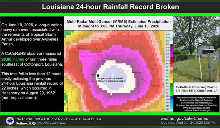
Twenty-nine inches of rain in a day is not a typo. A rain gauge three miles southeast of Cottonport clocked 29.06 inches in a 24-hour stretch on Thursday, a total meteorologists say sets a new Louisiana state record. The torrent, tied to the lingering remnants of Tropical Storm Arthur, swamped low-lying roads and left parts of central Louisiana literally standing in water. National Weather Service staff and the Louisiana state climatologist inspected the volunteer CoCoRaHS gauge in person and confirmed the reading, while NOAA’s climate archives will handle the final verification. Down the road in New Orleans, the airport still managed to pile up more than eight inches during the same event.
How the record was verified
Meteorologists from the National Weather Service office in Lake Charles and State Climatologist Jay Grymes signed off on the 29.06-inch total after a site visit to the volunteer CoCoRaHS station, according to WAFB. Gauge owner Matt Carnicle told the station he had to empty the instrument twice as the water neared its capacity, a detail that raised eyebrows but held up under scrutiny. Officials pointed out that multiple nearby stations also reported more than 20 inches, which boosted confidence that the monster reading was real and not a fluke. Video coverage first highlighted by WWLTV shows the on-site inspection and the gauge overtopping from the deluge.
Rainfall footprint and other totals
The storm summary from the Weather Prediction Center lists Cottonport at 29.06 inches, Plaucheville at 22.53 inches, Simmesport at 17.66 inches and New Orleans International at 8.08 inches. The numbers sketch out a bull’s-eye of extreme rain from central parishes toward the coast. The Weather Prediction Center also flagged torrential hourly rainfall rates and widespread flood warnings that lit up the region while Arthur’s leftovers parked overhead.
Why meteorologists say this was extreme
Louisiana State Climatologist Jay Grymes told WAFB that both the total amount and the pace of the rainfall far exceed NOAA’s estimated 1,000-year recurrence interval for a 12-hour event, putting this episode firmly in the “exceptionally rare” bucket. PRISM precipitation maps and local estimates show that much of the northern Gulf Coast had already picked up at least 20 inches of rain since May 1, which left soils saturated and rivers ready to respond quickly once Arthur’s remnants rolled through.
What this means for New Orleans' drainage
The Sewerage & Water Board of New Orleans said crews lowered canal levels and pre-staged pumps ahead of Arthur and reminded residents that the city’s drainage system is built to move roughly an inch of rain in the first hour and a half. Anything more intense than that can quickly put water on the streets, according to a SWBNO statement. New Orleans International’s 8.08-inch total shows how localized tropical downpours can stress pump stations and underpasses even when the worst of the storm targets another part of the state, a pattern reflected in the broader totals compiled by the Weather Prediction Center.
What to watch next
Forecasters expect a ridge of high pressure to build into the weekend, which should knock down rain chances even as the heat and humidity crank up, according to WBRZ. Local officials are still urging people in flood-prone neighborhoods to clear catch basins, steer clear of driving through standing water and stay tuned to updates from the National Weather Service and emergency management partners as the region dries out and takes stock.


