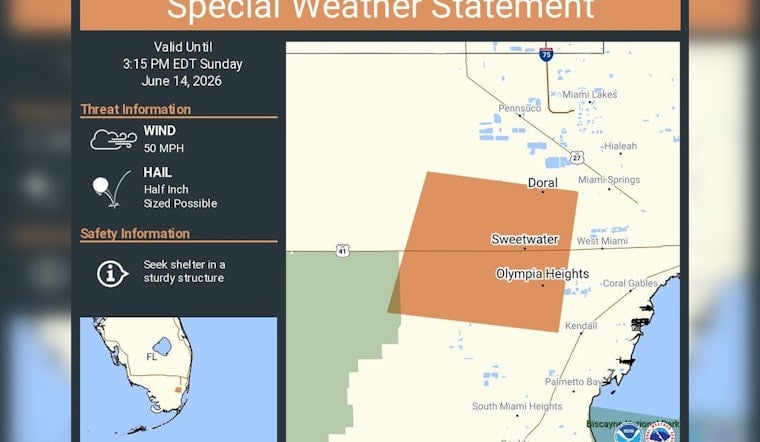
Residents in Doral, Sweetwater and Olympia Heights were told to drop the outdoor plans and head inside Sunday afternoon as the National Weather Service issued a special weather statement warning of gusty storms through 3:15 p.m. EDT. Forecasters said the strongest cells could pack damaging wind gusts and small hail, enough to knock down tree limbs and send any unsecured patio furniture on a short trip down the block.
The alert, posted Sunday afternoon, lists wind gusts up to 50 mph and hail up to 0.5 inch as the main hazards and is valid until 3:15 p.m. EDT, according to NWS Miami. Meteorologists urged people to move into a sturdy structure and warned that radar showed the storm core pushing into western Miami-Dade. The more intense pockets of the storm could bring frequent lightning and brief power interruptions.
A special weather statement has been issued for Doral FL, Sweetwater FL and Olympia Heights FL until 3:15 PM EDT https://t.co/2AogegakQT
— NWS Miami (@NWSMiami) June 14, 2026
Where the Threat Is Concentrated
The statement calls out Doral, Sweetwater and Olympia Heights by name, effectively putting neighborhoods along the Palmetto Expressway corridor on weather watch. Similar cells earlier this month have already produced 50 to 60 mph gusts and small hail, leading to downed limbs and temporary outages, as reported by Local 10. With storms that can ramp up quickly, forecasters say keeping an eye on local radar is the best way to tell whether the core is headed straight for your block or just skirting by.
How to Stay Safe
If you're in the warned area, the advice is simple: get indoors, stay there and keep away from windows until the worst has passed. The National Weather Service also urges residents to secure loose outdoor items, avoid flooded or ponding roadways and remember that lightning can strike well away from the main rain core, per NWS Miami. Anyone who sees downed power lines or other hazards should report them to local authorities and keep an ear on official channels in case the situation escalates to a more serious warning.


