Houston is kicking off Friday (June 12, 2026) in full swamp mode: temperatures are sitting near 80°F with light rain and patchy fog cutting visibility to about 4 miles. Dewpoints are parked in the upper 70s, so the air feels thick and sticky, and the morning drive may be sluggish in spots. Toss an umbrella in the car and budget a little extra time for both surface streets and the freeways.
Afternoon Heat And Humidity
Both Friday, June 12, and Saturday, June 13, are expected to top out around 94°F under mostly sunny skies. Factor in the humidity and it will feel hotter, with heat-index values in the upper 90s to triple digits across much of the metro. Some neighborhoods could feel as sweltering as 109°F, and the National Weather Service is flagging feels-like temperatures in the 97 to 107°F range through the weekend, a serious heat-stress setup for outdoor workers and older residents, according to NWS Houston/Galveston.
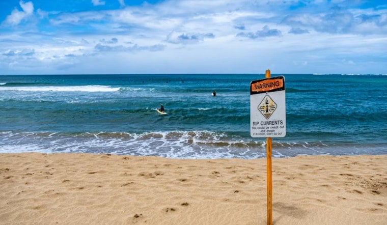
Coast: Rough Surf And Rip Currents
Down along the Gulf, lifeguards and forecasters are sounding the alarm about rough surf and a high rip-current risk for Gulf-facing beaches through Friday morning, June 12. Swimming will be unsafe in many areas, and long, confident swims away from shore are a bad idea. If you are still set on a beach day, stay close to lifeguard stands and follow the flag system, since strong currents can pull even strong swimmers off their feet. For local beach guidance, see our earlier Hoodline story: Gulf Surf Turns Nasty.
Thunderstorms And Flooding Risk
A front sliding in late Sunday will crank up rain and thunderstorm chances from late Sunday night (June 14) into Monday (June 15), with more rounds possible through Tuesday (June 16). The National Weather Service expects scattered to widespread thunderstorms, with most spots picking up around 1 to 3 inches of rain and isolated pockets near 5 inches. Those higher totals could trigger flash flooding in low-lying urban areas, so it is smart to stay on top of forecasts and steer clear of driving through standing water, according to NWS Houston/Galveston.
What To Do
Try to schedule heavy outdoor chores for early morning or evening, keep water handy and check in on neighbors who might struggle in the heat. If you are heading to the coast, swim near lifeguards and respect the warning flags. On the roads, ease off the gas when sudden downpours roll through and never attempt to drive across flooded streets. Keep an eye on local forecasts and advisories as conditions evolve through the weekend and into early next week.


