Storm chasers rolled out across central and southern Oklahoma on Saturday night as a line of severe thunderstorms marched through the region, pounding communities with large hail, damaging wind gusts and a series of tornado warnings. Radar and chase video showed storms firing off frequent lightning and rapidly growing hail, while local crews reported widespread power outages across the Oklahoma City metro and surrounding towns. KOCO 5’s live coverage followed the storms from the open plains into more populated areas, giving viewers a close, sometimes unnervingly intimate look at the night’s most dangerous cells.
As reported by First Alert Ride-Along coverage, the station’s storm-chase streams featured field crews working hand in hand with meteorologists in Storm Command and Sky 5, while chasers Amanda Benton, Jason Hill and Shane Helton zeroed in on the strongest parts of the line. KOCO’s coverage noted that the team was tracking rotation and watching hail rapidly intensify even when the main threats early on were big hailstones and wind gusts in the 60 to 70 mph range.
Watches, Warnings and Impacts
The National Weather Service issued multiple tornado and severe thunderstorm warnings for counties across central Oklahoma as the squall line pushed east. Forecasters also posted flash flood warnings where storms repeatedly moved over the same saturated areas. The official warning texts and lists of affected counties are available from the National Weather Service.
KOCO’s live updates tracked the fallout in real time. The station reported that utilities logged thousands of customers without power in sections of the Oklahoma City area and in Shawnee while crews began the slow work of restoration. According to KOCO’s reporting, the event came in two distinct waves: an earlier round focused on hail and wind, followed by a later band that dropped heavier rain and triggered pockets of localized flooding.
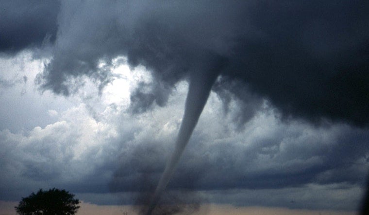
On the Ground With Chasers
Out in the field, chasers reported brief wall clouds, rapid hail growth and almost nonstop lightning as the storms matured. That kind of ground truth is not just dramatic video; it helps forecasters confirm radar-indicated rotation and sharpen the language and timing of warnings. KOCO’s veteran chasers drew on years of local experience to stay out of harm’s way while still documenting storm structure and movement for viewers, emergency managers and anyone trying to decide whether to stay put or head to shelter.
Where This Fits in the Season
The Storm Prediction Center and regional forecasters had already been flagging a multi-wave pattern favoring scattered severe storms across the southern Plains. Recent convective outlooks highlighted the potential for hail, damaging wind and a few tornadoes, which is why forecasts leaned heavily on hail and wind as the primary concerns, with flooding as a secondary issue once storms slowed down over the same spots.
Safety Reminders
The National Weather Service’s standard safety playbook still applies whenever the warnings start flying: “For your protection move to an interior room on the lowest floor of a building,” and stay away from windows until the storm passes. Before you hit the road, check the latest NWS products and local TV updates for county-by-county warnings, and if you encounter downed lines or blocked roads afterward, give repair crews extra space so they can work quickly and safely.


