

























































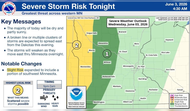
Wednesday is serving up classic summer-in-the-city weather in Minneapolis, starting warm and bright with temperatures around 66°F at Minneapolis–Saint Paul International Airport and heading toward a sunny afternoon high near 85°F. South winds will crank up through the day, so it will feel a bit hotter than the numbers suggest. Most of the daylight hours stay dry, but a band of storms is lining up to roll through after midnight.
Afternoon Winds Pick Up
South winds of 5–15 mph are expected this afternoon, with gusts building to around 25 mph by evening in more exposed spots. The National Weather Service Twin Cities highlights a breezy setup and a warming trend, so this is a good time to secure patio furniture, trash bins and anything else that might try to relocate itself. Drivers can expect gusty crosswinds on bridges, and cyclists or anyone with evening outdoor plans should be ready for the wind to ramp up after about 3–5 p.m.
Late-Night Thunder Risk
Shower and thunderstorm chances climb after midnight into the early hours of Thursday, with the most likely window currently pegged between midnight and 3 a.m. Some storms could pack strong wind gusts and brief heavy downpours. The Storm Prediction Center has parts of western Minnesota in a Slight Risk for severe storms, mainly for damaging winds. If you are out late or have tents and gear set up, get them tied down or moved inside before sunset so you are not doing it in the dark with thunder rumbling.
Thursday Through The Weekend
Thursday looks unsettled, with around a 50% chance of showers and thunderstorms and a high near 81°F. Friday brings additional storm chances before a drier pattern returns. Temperatures are expected to climb into the mid-to-upper 80s by Sunday and early next week, setting up a noticeably warmer stretch. Exact timing of storms is still a bit uncertain, so keep an eye on updated forecasts if you have outdoor plans Thursday night or Friday.
What To Watch
Secure loose patio furniture and décor, build in a little extra travel time if you are driving after dark, and have a quick plan to move tents or equipment inside if storms arrive overnight. Stay tuned to local radar and official updates for any watches or warnings, especially after sunset. For immediate alerts, check the National Weather Service and local emergency channels.





