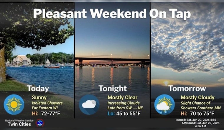
Minneapolis woke up to a postcard start on Saturday, June 20, 2026, with clear skies, temperatures in the mid 50s at Minneapolis–Saint Paul International Airport and a light northwest breeze. Expect a sunny, comfortable day with a high near 75°F and northwest winds around 5–10 mph. Humidity is low and overnight lows will slide into the low 50s, so a light layer is a good idea if you are headed to the lakes this evening. No watches or warnings are in effect this morning.
Weekend Snapshot
Saturday stays dry and pleasant across the metro, with only a few puffy cumulus clouds popping up this afternoon. Sunday turns partly sunny with a high near 76°F and just a slim shot at a shower, mainly across far southern Minnesota, as winds ease and turn more easterly. For most of the Twin Cities, outdoor plans through the weekend should roll along without weather drama.
Midweek Rain And Timing
The next round of widespread rain lines up for Tuesday, June 23, 2026, as a low pressure system and cold front pull moisture into the Twin Cities. Forecasters expect showers and thunderstorms to develop after about 7 a.m., with roughly an 80% chance of precipitation and periods of steady, occasionally heavy rain possible. According to the National Weather Service, the thunder risk looks limited, but brief heavy downpours could still slick up the roads and cause some localized ponding.
Plan Ahead
Commuters should budget extra travel time Tuesday and into Tuesday night, since heavier bursts of rain can quickly knock down visibility and make surfaces slippery. If you have midweek outdoor events, consider a backup plan or rain date, since we first flagged this setup in our one nice day before a midweek soaker update on June 14, although the timing has nudged earlier into Tuesday. Keep an eye on morning forecasts for any watches or warnings that might be issued before you hit the road.
Looking Ahead
Temperatures should run a few degrees below normal through much of next week, with highs in the mid 70s to upper 70s and overnight lows in the mid 50s. A few leftover showers may linger into Wednesday before the pattern gradually dries out and moderates toward next weekend.


