Central and western Oklahoma might catch a rare treat in the sky Thursday night, with the northern lights poised to creep far enough south to brush the Plains. The catch: scattered clouds, thick humidity and an approaching line of storms all threaten to turn the big aurora moment into a blink‑and‑you‑miss‑it event. On top of that, forecasters expect showers and scattered storms to hang around into the weekend, setting up a soggier stretch for much of the state.
What NOAA Is Predicting
NOAA’s Space Weather Prediction Center is calling for elevated geomagnetic activity, with planetary K‑index (Kp) values generally in the 5 to 7 range. Numbers like that can push the auroral oval much farther south than usual, opening the door for a faint glow to show up over Oklahoma if everything lines up. The agency’s three‑day geomagnetic outlook includes periods with those Kp values for the target nights, which bumps up the odds of at least a low‑key aurora over the state if skies cooperate. Whether the auroral oval actually dips into the Plains will depend on real‑time maps, according to NOAA/SWPC.
Weather Outlook: Clouds and Showers Could Spoil It
The National Weather Service office in Norman expects an unsettled pattern to linger, with daily chances for showers and thunderstorms across central and western Oklahoma through the weekend. Some of those storms could bring locally heavy rain and gusty winds. That means even if the geomagnetic storm hits its stride overhead, clouds and thick humidity may still kill the view for a lot of neighborhoods. Skywatchers are urged to check both conditions outside and the latest radar before driving out to darker spots, per NWS Norman.
Timing: Friday Evening Line, Early Saturday Showers
Forecasts from KOCO’s First Alert team show a line of storms developing Friday evening, roughly between 4 p.m. and 6 p.m., stretching from Seiling to Elk City. As that line weakens, it could still kick out some strong winds. KOCO also highlights early Saturday showers tracking north across Oklahoma, with activity moving through Oklahoma City, Norman and Pauls Valley around midday. Rainfall totals for central, southern and eastern parts of the state are projected to land between about 0.5 and 1.5 inches over the weekend. KOCO meteorologist Damon Lane also notes that a late sunset, lingering haze and sticky humidity may further cut the odds of spotting the aurora from inside city limits, as reported by KOCO 5.
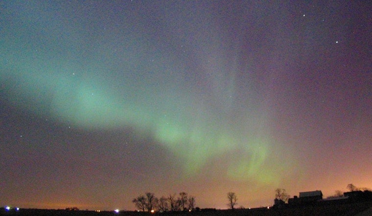
How To Try To Catch It
For those determined to hunt the lights, the game plan is simple but not exactly glamorous: find a dark location with a wide open view to the north after sunset, then lower your expectations. Under marginal geomagnetic conditions, the aurora in Oklahoma may show up as a faint green or gray haze that looks better in long‑exposure photos than to the naked eye. Check the Space Weather Prediction Center’s short‑term aurora forecast maps for near‑real‑time OVATION model guidance, and pair that with local NWS radar to confirm that clouds are not parked overhead. Light pollution and nearby storms can completely hide a display, even when the models look good. If the weather and space weather both cooperate, rural parts of northwest and western Oklahoma will offer the best shot at catching anything visible from the state.


