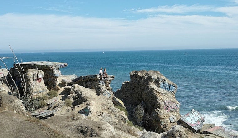
San Pedro’s fabled Sunken City, a cliffside maze of shattered streets and broken pipes left behind when a neighborhood slipped seaward nearly a century ago, could finally see a legal reopening. City engineers are now drawing up safety plans for the upper bluff, and the City Council has put up seed money this year to study monitoring and fencing. For the moment, though, the ruins remain off-limits, and anyone climbing the fence is subject to trespassing citations and the kind of cliff rescues that have kept local firefighters very busy over the years.
On Feb. 17, the Los Angeles City Council signed off on a motion that shifted money into the Bureau of Engineering for design work and consultant monitoring: $140,000 for engineering plans and $40,000 for a new “Sunken City Consultant Services” account, according to the city’s official file. Los Angeles City Clerk records show the transfer was approved under Council File No. 26‑0166. Council staff and Councilmember Tim McOsker’s office have told reporters that the effort will involve a redesigned fence and environmental monitoring, and Sophie Gilchrist, McOsker’s communications director, told LAist the project "may take another full year."
How the landslide happened
The trouble at Point Fermin started in 1929, when a water line reportedly broke beneath a house and a crack opened near Pacific Avenue and Paseo Del Mar, tearing through foundations and utilities. Over the following years, heavy storms sped up the slow-motion slide, and the city ultimately chose to buy most of the damaged lots rather than allow residents to rebuild. Officials later fenced off the area to keep thrill seekers from wandering onto the unstable ground.
By the late 1980s, the upper bench of the slide had its own fence as the ruins morphed into a notorious, if forbidden, hangout spot. Contemporary coverage and later retrospectives trace the saga over decades, as documented by the Los Angeles Times and SFGATE.
Why the bluff remains risky
Geologists say the Palos Verdes and Point Fermin bluffs sit on weak clay layers and feature steep, eroding faces that are prone to sudden failure, which is why officials urge caution even on the seemingly solid upper bench. State mapping and hazard reports describe large landslide complexes throughout the area and require site-specific investigations before public access is allowed.
The California Geological Survey’s Seismic Hazard Zone Report, along with other technical studies, warns that the lower ruins remain unstable and that any public use has to be confined to engineered, monitored sections. California Geological Survey
What reopening could look like
McOsker and nearby residents have floated a compromise: open only the more stable upper acre or so, with a short, daylight-only trail, new fencing, and hazard mitigation, while keeping the broken streets and rubble below off-limits. City Hall filings and local reporting describe a recent interview in which McOsker laid out a “simple” concept to level the top bench, clear obvious trip hazards, and add a gated entry that would be unlocked during the day.
Even if that public path is designed, officials say it would still need coastal permits and ongoing monitoring before anything on the ground actually changes, as described by the Daily Breeze.
Until designs are finalized and coastal permits are in hand, the existing fences stay put, along with the risk of falls that have already prompted multiple cliff rescues. Visitors are expected to treat Sunken City as closed, and emergency crews and news outlets have repeatedly documented serious tumbles at the Point Fermin cliffs. Authorities urge anyone who notices new cracking or slumping to report it so engineers can track changes and keep the surrounding neighborhood safe. ABC7


.jpg)