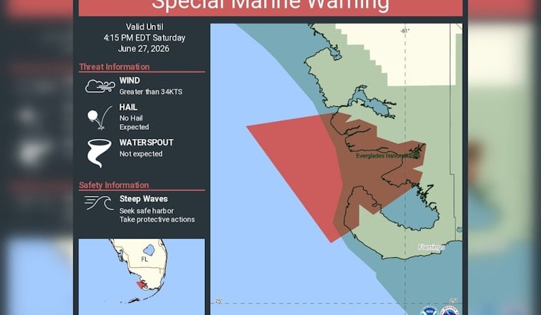
Boaters skirting the edge of Everglades National Park got a rude Saturday afternoon wake-up when the National Weather Service office in Miami fired off a Special Marine Warning for Gulf-side coastal waters from East Cape Sable to Chokoloskee, out 20 nautical miles. The alert, in effect until 4:15 p.m. EDT on June 27, called out winds topping 34 knots and steep, hazardous seas, and urged anyone on the water to high-tail it to safe harbor.
Marine warning covers Everglades Gulf waters
According to NWS Miami on X, the Special Marine Warning was focused on the stretch of coastal waters from East Cape Sable to Chokoloskee out to 20 nautical miles and remained in effect through 4:15 p.m. EDT on June 27. Forecasters told mariners in the path of the storms to take immediate protective action and get into sheltered waters while the cells pushed through the area.
What the alert asked boaters to do
According to the National Weather Service, Special Marine Warnings are short-fuse alerts issued when thunderstorms over the water kick up dangerous conditions such as sustained winds or gusts of 34 knots or higher and sharply building waves. The advisory language is blunt: mariners are told to move to safe harbor and stay put until the hazardous weather passes.
The U.S. Coast Guard gives similar guidance for pleasure craft when weather turns nasty, advising boaters to seek shelter quickly and keep a close ear on VHF channel 16 as conditions deteriorate. NOAA notes that waterspouts and sudden squalls can spin up fast in warm summer waters, warns boaters never to approach a waterspout, and encourages people on the water to report hazardous conditions to help with any needed search and rescue coordination.
Why the Everglades coast flares up fast
Along South Florida’s southwest coast, daytime sea-breeze boundaries colliding with warm Gulf waters and sticky summer humidity often trigger isolated yet intense thunderstorms. Those pop-up squalls are just the kind of hit-and-run storms that can prompt Special Marine Warnings. Because they are highly localized and can ramp up quickly, they are especially risky for small boats and paddlers who may not have much time to react. Weather.com notes that these quick-firing summer thunderstorms are among the hardest types of weather to pinpoint in advance.
For anyone boating or visiting marinas along the Everglades coast, the takeaway during a Special Marine Warning is simple enough: stay off the water while the alert is active, secure vessels at the dock, and keep radios tuned to official channels. Ongoing updates come through marine forecasts and local harbor notices, along with official social media feeds for any new warnings or cancellations.


