It is a mostly clear and muggy start across Minneapolis–Saint Paul this Wednesday morning, with temperatures near 70°F and dew points in the mid 60s. After the quiet wakeup, forecasters are watching for multiple rounds of thunderstorms today, with an early disturbance and a stronger line expected to redevelop by midday and intensify into the afternoon and evening. Anyone counting on dry skies for the workday or outdoor plans should stay flexible, as heavy rain, frequent lightning and gusty winds could disrupt travel and events.
When Storms Are Likely
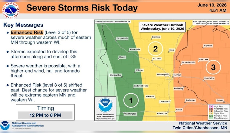
The National Weather Service expects the main window for showers and thunderstorms in the Twin Cities to run from late morning into the early evening on Wednesday, with the highest odds from midday into mid afternoon. Forecasters note that some storms could turn severe, bringing damaging straight line winds, large hail and isolated tornadoes. The agency also highlighted an overnight squall line in parts of the Dakotas that produced very strong gusts, a reminder of the punch these systems can pack.
Commute and Event Impacts
Downpours at peak intensity may quickly reduce visibility and lead to localized flooding on low lying streets, which can slow traffic and catch drivers off guard. Gusty winds could knock down tree branches and cause scattered power outages, while larger hailstones may damage vehicles and property in the strongest cells. Riders and drivers should build in some extra time to reach their destinations and keep an eye on updates from Metro Transit. Organizers and attendees for outdoor gatherings may want backup indoor options ready to go.
What Comes After
Behind the front, temperatures will trend cooler, with highs dipping into the 70s on Thursday as drier air begins to settle in by Friday. Conditions should improve later in the week. A few leftover showers are still possible Thursday afternoon, but Friday and the weekend currently look generally milder and less humid. Forecast details can change as storm tracks wobble, so checking in on updated local forecasts will be important.
Safety Tips
During severe storms, move indoors, stay away from windows and wait for the worst of the weather to pass. Avoid driving through standing water, since it can be deeper than it looks, and treat any downed power lines as live, reporting them to authorities. If you have outdoor plans this afternoon or evening, consider shifting activities inside or rescheduling, and secure loose items in yards or on balconies before winds start to pick up.


