

























































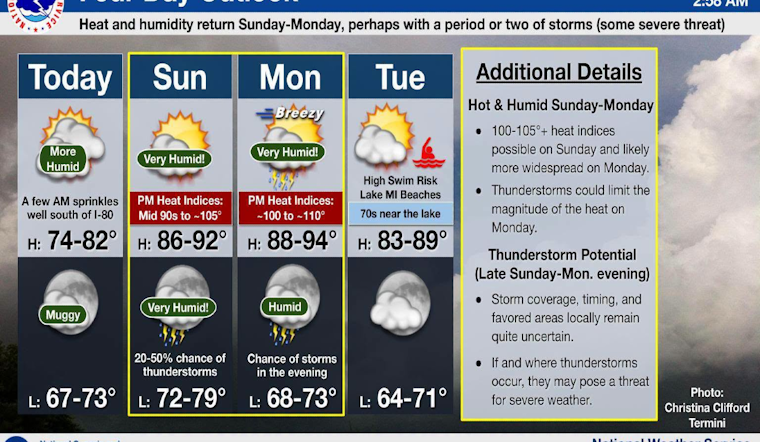
Chicago woke up to muggy, mostly cloudy skies Saturday, with temperatures stuck in the mid-60s and a light south-southwest breeze already hinting at what is coming next. Today is the relative breather before the real heat returns, with highs near 78°F. By Sunday and Monday, humidity will spike, turning outdoor holiday weekend plans from comfortable to downright soupy as richer southerly moisture moves in. Showers or thunderstorms are possible from late Sunday into Monday night.
Today Through Monday
For Saturday, expect mostly cloudy skies, south-southwest winds around 5-10 mph with gusts up to 20 mph, and a high near 78°F. Sunday is the first legitimately hot day, with highs near 90°F and heat index values pushing into the upper 90s. Monday looks hotter still, with highs in the low 90s and heat indices that could climb into the 100s.
On top of the heat, there is a growing chance for showers and thunderstorms from Sunday night into Monday night. Any stronger storms could deliver heavy rain and gusty winds, especially Monday when southwest winds may gust up to 30 mph. These details come from the latest forecast and discussion from the National Weather Service.
Storm Timing And Uncertainty
The tricky part is timing. Coverage and exact placement of storms are still uncertain, and small shifts in the atmosphere could focus the stronger cells either along the lakeshore or farther inland. That low predictability keeps the door open for isolated severe storms, so event organizers and outdoor workers should have backup plans ready if activities run into Sunday night or Monday evening.
If storms do organize, expect quick-hitting downpours, frequent lightning, and pockets of strong wind capable of knocking down tree limbs and causing localized flooding. Keep an eye on watches and warnings, and be ready to head indoors on short notice.
Cooling Centers And Safety Tips
For anyone who may struggle with the weekend heat, the city operates a network of air-conditioned cooling centers and other public facilities. Locations and up-to-date listings are available on the city’s cooling-center map or by calling 311, according to the City of Chicago.
Basic heat safety still matters: drink water often, look for shade during the afternoon peak, and postpone heavy outdoor work when you can. Employers and event planners should build in extra water breaks. Transit riders may run into brief delays if stronger storms flare, and lakefront visitors should be ready for choppy water and changing conditions as winds pick up later in the weekend.
More From Hoodline
We recently took a broader look at Chicago’s summer heat patterns and local cooling resources; for that background, see our earlier report on the recent heat and cooling resources. We will update this story if the forecast or any watches change. If you have outdoor plans, check local forecasts again Sunday morning. Stay cool and plan ahead.




