

























































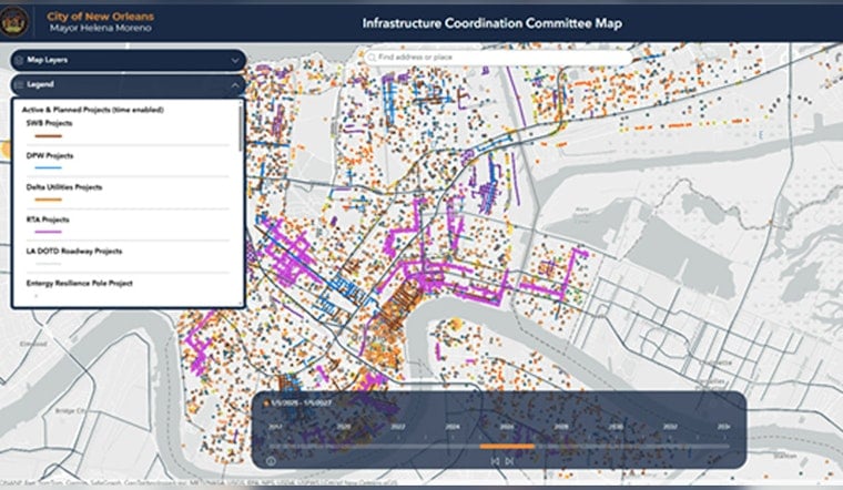
The City of New Orleans on Wednesday rolled out an interactive dashboard that lets residents and business owners track neighborhood infrastructure and utility projects block by block. Officials are billing the tool as a one-stop map meant to cut down on overlapping construction and spell out clearer timelines for when streets, sidewalks and underground work will wrap up. The launch comes as city leaders push to move long-delayed capital work across neighborhoods out of the planning phase and into the finish column.
What the dashboard shows
Users can pull up active and planned capital projects, Sewerage and Water Board maintenance orders and other infrastructure activities on a single map, according to New Orleans CityBusiness. Each project listing flags which agency is in charge and links out to more detailed project pages and contact information. CityBusiness reports the dashboard was built by the Infrastructure Coordination Committee to fold several public-facing lists into one centralized view.
Who updates it and how often
The Sewerage & Water Board's work-order map, which feeds into the unified view, is updated weekly, according to the Sewerage & Water Board of New Orleans. Other agency and roadwork project layers refresh on a monthly schedule, per the city's roadwork mapping application. Officials said the blended update cycle is meant to reflect both quick-turn repair jobs and the slower timelines that come with major capital projects.
Why officials say it matters
Deputy Chief Administrative Officer for Infrastructure and Department of Public Works Director Steve Nelson said the new tool is designed to keep agencies from working at cross-purposes, calling it a "one-stop location" for residents and service providers, according to New Orleans CityBusiness. Participating organizations, CityBusiness notes, include the Department of Public Works, the Sewerage & Water Board, Entergy, Delta Utilities, AT&T and the Louisiana Department of Transportation and Development.
Neighbors say they need it
Advocates and business owners welcomed the new transparency but cautioned that timelines on a screen will not mean much without steady follow-through. Anthony Jackson, a New Orleans East advocate, told WGNO that projects would sometimes start and then be put on hold with residents left in the dark. Steve Smith, owner of Turtle Bay, told the outlet that "completion for our section will be about summer of 2026 and other blocks in fall of 2026."
How to find it and give feedback
The dashboard is available through the city's apps and maps page and will also be linked from agency project pages, according to the online tools listing at City of New Orleans Apps & Maps. Officials said they plan to gather user feedback to tighten up project descriptions and improve scheduling accuracy. Residents are encouraged to check the map before planning events or deliveries on blocks that are marked as construction zones.
City leaders acknowledged that the tool will not make construction headaches disappear, but said more visibility into what is planned and when it is supposed to happen should help residents plan and hold agencies accountable. Officials urged users to treat the map as a planning guide and to report any discrepancies to the agencies listed on each project page.





