

























































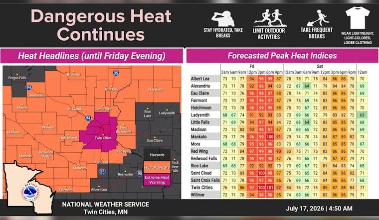
Minneapolis is baking Friday, July 17, with clear skies this morning and temperatures around 79°F at Minneapolis–St. Paul International. Forecasters expect the high to climb to about 97°F this afternoon, with heat index values near 101°F. Overnight lows will only slip into the low 70s, and wildfire smoke has pushed air quality into unhealthy to hazardous ranges across parts of central Minnesota.
Heat And Air Quality Alerts
The National Weather Service has an Extreme Heat Warning for the Twin Cities metro, including Hennepin County, through 9 p.m. Friday, and forecasters show highs near 97°F with heat index values around 101°F, according to NWS Twin Cities. The Minnesota Pollution Control Agency has issued Air Quality Alerts for fine particle pollution and says readings have reached “Very Unhealthy” to “Hazardous/Maroon” levels in places; people with lung or heart disease, older adults and children should remain indoors, per the MPCA.
Afternoon And Tonight
Expect bright, hot conditions through the afternoon with southwest winds 0–15 mph and temperatures peaking around 95–97°F. Humidity will make it feel closer to 100–101°F by mid to late afternoon. A slight chance of showers and thunderstorms, about 20 percent, is possible between roughly 8 p.m. and 10 p.m., then skies should clear and drop to the low 70s overnight, so there will be little overnight relief. If you work outside, plan frequent shade breaks and extra water during peak heating.
Where To Stay Cool
Public libraries, community centers and park splash pads are the fastest options for air conditioned relief, and the Minneapolis Park & Recreation Board lists dozens of wading pools and open swim sites for hot afternoons. If you must remain outdoors for work, shift strenuous tasks to early morning or evening and take regular rest breaks. Never leave children or pets in parked cars, and call 911 immediately if someone shows signs of heat stroke.
This story updates our earlier coverage from July 14; for background on the heat watch and a list of air conditioned public locations see our heat wave preview. We will post updates if alerts or smoke patterns shift through the weekend.





