

























































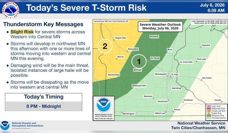
Strong to severe thunderstorms are lining up for much of Minnesota from Monday night through Wednesday, with central Minnesota in the bullseye for the heaviest downpours and the highest flood risk. The incoming system is tapping into a very humid, unstable air mass that could spin up damaging wind gusts, large hail and quick, intense bursts of rain. Areas that already took a soaking over the weekend are especially vulnerable, since soils there are already saturated.
According to the National Weather Service Twin Cities, a line of strong to severe storms could fire up late Monday in western Minnesota and march east, with the potential for damaging winds, large hail and torrential rainfall. The Storm Prediction Center Day 2 outlook places parts of southwest Minnesota in a slight risk for organized severe storms as a stalled front collides with abundant moisture. Forecasters note precipitable water values near 2 inches and persistent instability, conditions that favor very heavy rain rates where storms repeatedly track over the same neighborhoods.
Where the risk is highest
Central Minnesota, including the St. Cloud area along the I-94 corridor, is being singled out for repeated heavy showers and the potential for urban and low-land flooding. According to WJON, St. Cloud's Sky Central Airport has already picked up about 4.84 inches of rain for the June-July period, with many neighborhoods seeing even higher localized totals during the weekend storms. If new cells unload intense rain over those already soaked spots, forecasters warn that flash flooding and flooded roadways are likely.
Drought and flood at the same time
The latest U.S. Drought Monitor update shows roughly 72 percent of Minnesota is abnormally dry, about 30 percent is in moderate drought and 12 percent is in severe drought. Meteorologists caution that intense, short-lived downpours can trigger flash flooding on hardened or compacted ground even as they deliver badly needed moisture to parched areas, a paradox the Drought Monitor summary highlights for parts of the Upper Midwest.
What residents should watch for
Stay close to official forecasts and be ready to move to higher ground if water starts pooling near homes or roadways, and never drive through flooded streets. Secure loose outdoor items, charge devices and turn on local weather alerts on your phone so you see watches and warnings as they are issued. If sirens sound or local authorities order evacuations or sheltering, treat those as immediate instructions to seek safety.
Exactly when and where the strongest storms will hit is still uncertain, and updates, watches or warnings could be issued late Monday and again from Tuesday into Wednesday. This story will be updated as official watches, warnings or reports of local impacts come in.




