

























































Minneapolis woke up Sunday, July 5, 2026, to a foggy, muggy start that felt more like a sauna than a summer morning. At Minneapolis-Saint Paul International Airport (KMSP), observers logged fog and mist, about 66°F, and visibility near 6 miles. The gray veil is expected to lift quickly after sunrise.
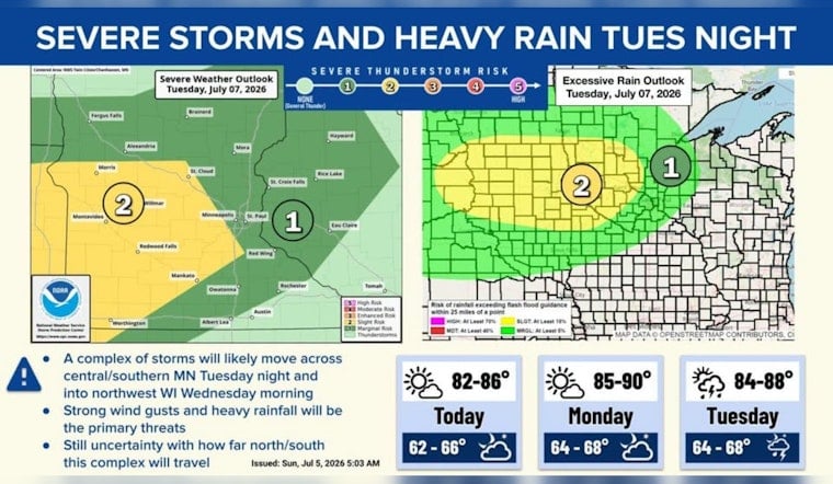
Once the fog fades, today will lean mostly sunny with a high near 86°F. Expect patchy fog before 7 a.m., then a slight chance of showers and thunderstorms between 1 p.m. and 5 p.m. Rain chances sit around 30 percent, with new rainfall generally under a tenth of an inch. Forecast guidance is also flagging a growing signal for a larger storm cluster late Tuesday night into Wednesday (Tuesday night, July 7, into Wednesday, July 8, 2026) that could deliver heavier rain - locally around one-half to three-quarters of an inch - along with the risk of damaging wind. According to the National Weather Service Twin Cities, anyone with outdoor plans later this week should keep an eye on forecast updates.
Plan Ahead For Heat And Rain
Monday, July 6, 2026, looks even hotter, with highs near 89°F and south-southeast winds around 5 to 10 mph. Tuesday stays on the humid side with similar temperatures, so it will not offer much relief. If the midweek storm system organizes as currently expected, some neighborhoods could see gusty winds and localized flooding late Tuesday into Wednesday, so outdoor events may want an indoor backup ready just in case. Hennepin County maintains a map of cooling and shelter options for residents who are sensitive to heat or who might lose power during storms.
What To Expect This Morning
Patchy fog will gradually burn off through mid-morning, giving way to mostly sunny skies and light east-northeast breezes this afternoon. Morning commutes should improve quickly, though low-lying areas near the Mississippi River and other waterways could hang onto the haze a bit longer. If you see lightning at any point, head indoors and avoid driving through standing water.
This updates our swampy weekend storm preview. We will post fresh updates if any watches or warnings are issued; for the latest official alerts, check the National Weather Service.



