

























































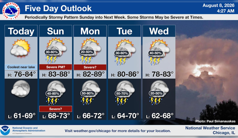
Chicago is getting a relatively easy Saturday, with mostly clear skies early, temperatures around 72°F and an afternoon high near 79°F. The calm weather is a welcome setup for outdoor plans, but the forecast takes a sharper turn starting Sunday.
Sunny Saturday, Cooler Near The Lake
Saturday should stay mostly sunny, with north winds of 5 to 10 mph and gusts reaching 20 mph. A lake breeze may keep neighborhoods near Lake Michigan in the mid-to-upper 70s, while some wildfire smoke could give the sky a milky look later in the day.
According to the National Weather Service Chicago, Saturday night will be mostly clear with a low around 68°F. A few early shower chances should fade quickly, and no watches, warnings or advisories are posted for the city or nearby lake waters.
Storms Return Sunday And Linger Into Midweek
Sunday brings a high near 85°F and a 50% chance of showers and thunderstorms beginning after 10 a.m. South-southwest winds may gust to 25 mph, and storms could become more numerous Sunday night, when the rain chance rises to 80%.
The unsettled pattern continues Monday, with an 80% chance of showers and thunderstorms and a high near 84°F. Storms remain likely Tuesday and possible Wednesday, with the weather service warning that some could bring damaging winds, hail, torrential rain and localized flash flooding.
Saturday is the best bet for picnics, errands and lakefront time before the storm chances ramp up. Anyone making plans Sunday through Wednesday should keep an indoor backup ready and check updated alerts if storms begin developing nearby.





