

























































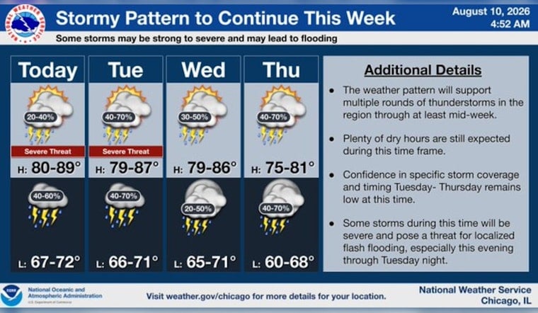
Chicago is starting Monday under mostly cloudy skies, sticky air and temperatures in the mid-70s, with a high near 79 degrees expected later today. Spotty showers and thunderstorms could develop from around midday through the afternoon, so the forecast is less “grab the sunglasses” and more “maybe pack the umbrella.”
Storm Chances Build Through The Afternoon
The chance of rain is about 30% Monday, with mostly cloudy conditions and light north winds. The National Weather Service Chicago forecast shows the storm threat increasing again tonight, when scattered showers and thunderstorms are possible and temperatures dip only to around 70 degrees.
Some storms through midweek could be strong to severe and produce locally heavy rain, according to the National Weather Service Chicago. No watches or warnings are listed in the current forecast, but repeated downpours could still create difficult conditions on roads and in low-lying areas.
Tuesday And Wednesday Look Wettest
Tuesday brings the highest storm odds of the week so far, with showers and thunderstorms likely, a high near 80 and a 60% chance of precipitation. Gusts could reach 15 mph outside the storms, while Tuesday night stays unsettled with another 60% chance of showers and thunderstorms.
Rain showers are likely Wednesday morning before the forecast trends partly sunny, with a high near 79. Thursday remains mostly cloudy with a 40% chance of showers and thunderstorms, while Friday looks cooler at about 74 degrees with only a slight chance of storms.
Weekend Plans May Need A Backup
The unsettled pattern may linger into the weekend, though temperatures should remain seasonable. Saturday and Sunday both call for highs near 77 with at least a chance of showers or thunderstorms, meaning outdoor plans may work best with a little flexibility built in.





