

























































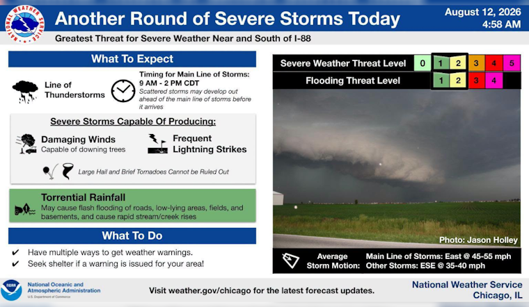
Central Chicago is starting Wednesday under mostly cloudy skies, patchy fog and temperatures near 72 degrees, but the calm opening could give way to a rougher midday. Showers and thunderstorms are likely before the afternoon winds down, with some storms capable of heavy rain and damaging wind gusts.
Storms Could Complicate The Midday Commute
The main storm window runs from mid-morning through mid-afternoon, when a fast-moving line of thunderstorms could sweep across the area. The National Weather Service Chicago/Romeoville says some storms may produce wind gusts in the 60-to-70-mph range across parts of the broader forecast area.
Chicago is expected to reach about 79 degrees before temperatures ease back toward the upper 70s. West winds will run 5 to 10 mph, and rainfall totals could reach a quarter to half an inch, with heavier pockets possible under the strongest storms.
No watches, warnings or advisories are listed in the forecast provided, but conditions may change quickly once storms develop. People heading out around lunchtime should allow extra travel time, keep an eye on alerts and move indoors if thunder becomes frequent.
Fog Gives Way To A Quieter Wednesday Night
Storm chances should drop sharply later Wednesday as the system moves away, leaving partly cloudy skies and a low near 70 degrees overnight. Winds will turn northeast at around 5 mph, and only a small amount of additional rain is expected.
Thursday Through The Weekend Stay Active
Thursday brings another round of unsettled weather, with rain showers possible from about 8 a.m. to 1 p.m. before showers and thunderstorms become more likely later in the day. The high should reach around 76 degrees, with a 50% chance of precipitation and possible rainfall totals between a half-inch and three-quarters of an inch.
Storm chances continue Thursday night, followed by a cooler Friday with a high near 76 and a chance of early showers. Friday night could bring more thunderstorms, while Saturday looks warmer near 82 degrees with storms likely before early afternoon and additional chances lingering into Sunday.
Dryer Weather May Finally Arrive Next Week
The forecast may turn a corner Monday, when mostly sunny skies and a high near 76 are expected. Tuesday should stay mostly sunny with a high around 79, offering Chicago a better window for outdoor plans before a slight chance of overnight showers returns.





