

























































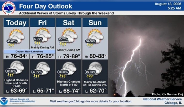
Chicago is waking Thursday to foggy, muggy air, with temperatures around 72 degrees near Midway and visibility reduced to roughly 4 miles. Patchy fog should ease by midmorning, but the gray skies are only the opening act for a stormier stretch.
Storms Move In Thursday Afternoon
Showers and thunderstorms could develop between 2 p.m. and 4 p.m. Thursday, with a 50% chance of rain overall. The high should reach about 77 degrees before temperatures slip into the low 70s, while east winds blow at 5 to 10 mph.
Rainfall could total a quarter to half an inch, with locally heavier downpours possible. The strongest storm threat is expected mainly south and southwest of Chicago, but any storms that reach the city could slow the afternoon commute and briefly reduce visibility.
Flood Risk Builds Overnight
Another round of showers and thunderstorms is possible Thursday night, with temperatures dropping to around 69 degrees and east-northeast winds near 10 mph. The National Weather Service Chicago says parts of northern Illinois and northwest Indiana are under a Flood Watch from Thursday evening through Friday morning.
Forecasters are watching for repeated rounds of heavy rain from Thursday night into Saturday, when some areas could receive several inches and flooding concerns may increase. Friday brings a 60% chance of showers and thunderstorms with a high near 77, followed by a warmer but still stormy Saturday with a high near 84 and a 70% rain chance.
Clearer Weather Arrives Monday
The unsettled pattern may finally loosen Sunday, though showers and thunderstorms remain possible through the day. Monday looks like the reset button, with mostly sunny skies, a high near 76 and a much lower rain chance before another modest warm-up Tuesday.





