

























































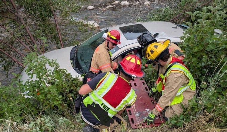
A single-vehicle crash in Logan Canyon nearly sent a car into the Logan River on Wednesday afternoon, but the driver walked away after being treated and released on scene by medical crews. Logan City Fire Department crews responded to the wreck near Temple Peak on U.S. Highway 89 just before 3 p.m., finding the vehicle off the road and resting in bushes along the riverbank.
First responders helped the driver, who was alone in the car, climb out of the vehicle after it left the roadway, according to KUTV. The station reported that the driver's identity was not released to the public, and details about what caused the car to leave the road were not immediately available. No further information on the cause of the crash has surfaced since.
A Narrow, River-Hugging Stretch of Utah's Longest Highway
The crash site sits within the Logan Canyon National Scenic Byway, a 41-mile stretch of U.S. 89 that traces the tight bends of the Logan River between steep limestone cliffs, according to background compiled by US Route 89. At 502 miles, U.S. 89 is Utah's longest highway, serving as the main link between Interstate 15 and Cache Valley, per the highway's Wikipedia entry on its Utah route. The corridor's narrow shoulders and sharp drop-offs toward the river have long made off-road departures particularly hazardous in this part of the canyon.
The stretch near Temple Fork, between mileposts 472.8 and 474.5, is an area the Utah Department of Transportation actively monitors as part of its ongoing infrastructure and safety work in the canyon. Past state crash investigations near the Temple Fork curve around milepost 474 have noted that dozens of vehicles have drifted off the roadway there during wet or icy conditions, according to reporting from The Salt Lake Tribune. Some of those past incidents required multi-agency technical rope rescues.
A Canyon With a History of River Plunges
This is not the first time a vehicle has come close to entering the Logan River from this highway. In May 2020, emergency crews rescued a mother and four children after their vehicle actually plunged into the river, according to Utah Public Radio. That incident underscored how quickly a routine drive through the canyon can turn into a swift-water rescue given the terrain's steep embankments.
Logan City Fire Department, which handled Wednesday's response, provides primary fire suppression and emergency medical coverage across Logan, North Logan, Providence, River Heights, and unincorporated Cache County, including Logan Canyon. All of the department's active firefighters are licensed as Advanced Emergency Medical Technicians or paramedics, according to information published by Logan City, allowing crews to deliver advanced life support directly at crash scenes rather than waiting for transport to a hospital. That level of on-site care is likely why Wednesday's driver could be treated and released without being taken to a medical facility.
State Rules Require a Formal Crash Report
Because the crash involved property damage and a vehicle leaving the roadway, Utah Department of Public Safety rules require law enforcement to investigate and file an official state crash report, a requirement that applies to any public road incident involving injury, death, or at least $2,500 in damage, per the Utah Highway Safety Office. That paperwork feeds into statewide crash data used to track hazard spots like the one near Temple Peak.
Statewide, expanded Utah Department of Transportation Incident Management Teams have improved emergency response times in recent years, with crews arriving at nearly two-thirds of highway crashes within 15 minutes as of 2020 performance data cited by the U.S. Department of Transportation. Fast turnaround matters in a corridor like Logan Canyon, where a stalled or wrecked vehicle can quickly become a secondary hazard on the narrow, winding route.
The area also borders high-altitude backcountry terrain leading toward Peter Sinks, a basin known for abrupt weather shifts and elevation changes, according to onX Offroad. Sudden changes in mountain driving conditions can alter road traction with little warning, adding another layer of risk for drivers navigating this stretch of Highway 89 during the summer recreation season.





