

























































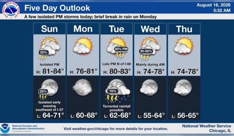
Chicago woke to a cloudy, muggy Sunday, with temperatures around 73 degrees before sunrise, and the forecast is keeping umbrellas on standby. Showers may linger through late morning, with another round of hit-or-miss showers and thunderstorms possible later in the day as the city warms to 83.
The morning storms could bring torrential downpours and locally gusty winds, with a quarter to half-inch of rain possible in some spots. A Flood Watch remains in effect until 10 a.m. Sunday for several areas near and south of I-80, where saturated ground means even a fast burst of rain could renew flooding, according to National Weather Service Chicago.
Storm Chances Fade Then Return
The rain risk drops sharply around midday, when skies stay mostly cloudy and temperatures climb through the upper 70s and low 80s. Another chance arrives after about 3 p.m., with better odds southeast of I-55; west winds of 5 to 10 mph may gust to 20 mph, and the overall severe-weather threat is low, though heavy rain remains possible.
Cooler Monday, More Storms Midweek
Sunday night brings only a slight chance of a shower or thunderstorm before 7 p.m., followed by mostly cloudy skies and a low near 70. Monday looks like the week's brief reset, with mostly sunny skies, a high near 76 and a low around 67 before temperatures rebound to 83 Tuesday.
The next more organized storm chance arrives Tuesday night into Wednesday, when showers and thunderstorms are likely. After that, the forecast turns drier and cooler, with mostly sunny skies and highs in the mid-70s Thursday and upper 70s Friday and Saturday.





