

























































A tornado believed to be at least an EF-2 tore through Chicago's south suburbs Tuesday, striking Glenwood, Thornton, Homewood and Flossmoor with winds reaching as high as 115 mph. The twister was rain-wrapped, meaning it could not be easily seen on the ground, and forecasters confirmed its presence using Doppler radar rather than visual spotting.
According to CBS Chicago, at least two tornadoes were on the ground Tuesday as a broader storm system moved through the region, with the potential for gusts as high as 120 mph. CBS News Chicago meteorologist David Yeomans described the intensity of the setup in stark terms, saying, “You can go your whole meteorological career without seeing one thunderstorm this strong, and here we have it.” The outlet's report was authored by web producer Adam Harrington, with CBS2 Chicago chief meteorologist Albert Ramon also covering the storm.
Why the Twister Vanished Into the Rain
The tornado's rain-wrapped nature is not a rare fluke but a recognized meteorological phenomenon. A rain-wrapped tornado forms when the rear-flank downdraft of a high-precipitation supercell wraps torrential rain around the rotating vortex, creating a dense curtain of precipitation that hides the funnel from anyone looking up from the ground, according to the National Weather Service. That means dual-polarization Doppler radar, capable of detecting rotation and lofted debris even through heavy rain, became the primary tool for confirming the tornado's existence rather than eyewitness reports.
Forecasters had flagged the danger well before the funnel touched down. Ahead of Tuesday's midday storms, the National Weather Service Chicago office warned that severe thunderstorms moving through between 9 a.m. and 3 p.m. could produce 80 mph wind gusts, localized flash flooding and isolated tornadoes, a warning Hoodline relayed in its own storm-threat coverage that morning. Chicago had opened the day with 75-degree temperatures and clear skies before the atmosphere rapidly destabilized into rotating storm cells.
Same Towns, Second Tornado in Two Weeks
For residents of Glenwood, Homewood and several neighboring communities, Tuesday's tornado was not their first brush with disaster this month. Just two weeks earlier, on July 27, a separate severe weather outbreak produced seven confirmed tornadoes across the region, including an EF-1 path that swept through Country Club Hills, Homewood, Glenwood, Hazel Crest, Markham and Harvey, according to the National Weather Service as reported in Hoodline's earlier coverage of a cancer-stricken tornado survivor left homeless. That earlier storm caused severe roof collapses and widespread power outages, leaving some residents still displaced when Tuesday's tornado struck the same corridor.
An EF-2 rating means the National Weather Service estimates the tornado's three-second wind gusts fell between 111 and 135 mph, placing it in the “strong” category on the Enhanced Fujita Scale and capable of causing considerable structural damage. That scale, adopted in 2007, was designed to align estimated wind speeds more closely with observed structural damage than its predecessor.
Part of an Unprecedented Stretch of Storms
Tuesday's tornado lands in the middle of what has become an extraordinary run of severe weather for Illinois. By June, the state had already logged 205 tornado reports out of 940 nationwide, an unprecedented pace that outstripped any full year in state history, per NBC 5 Chicago. Illinois had already led the nation in confirmed tornadoes in 2023 with 121 and in 2025 with 126, while setting a then-record of 142 in 2024.
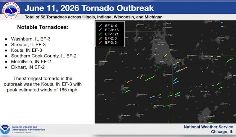
The National Weather Service Chicago office, which covers 23 counties, historically averages just 10 to 20 tornadoes a year, but recorded 58 in 2023 and 63 in 2024. A single-day outbreak on June 11 produced 24 confirmed tornadoes within that forecast area alone, the second-largest single-day outbreak in local recorded history, featuring an EF-3 in Streator and EF-2 damage in Indiana. The all-time record remains the July 15, 2024 derecho, which spawned 32 confirmed tornadoes in one day and 41 across 36 hours when combined with storms the night before.
Recovery Still Underway in Northwest Indiana
Tuesday's storm system also passed through Northwest Indiana, a region still rebuilding from the June 11 outbreak. In Merrillville, an EF-2 tornado that day caused severe structural damage to Andrean High School and surrounding commercial buildings, destroying the school's roof, ceilings and windows and forcing two months of intensive repairs ahead of its scheduled August 13 reopening, according to CBS Chicago.
Whether municipal crews in the south suburbs are now facing compounding strain from back-to-back tornado strikes in the span of two weeks remains an open question, as does the exact final track length of Tuesday's tornado, which awaits confirmation from National Weather Service damage survey teams. Exact power outage totals across Cook County and Lake County, Indiana, had not yet been tallied as of Tuesday afternoon.





