

























































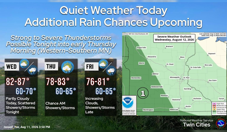
Minneapolis is waking to clear skies and temperatures near 72 degrees Wednesday morning, with one more warm, mostly dry day ahead before rain chances start stacking up. The high should reach about 88 degrees, so summer is not quite done making its case.
Wednesday Stays Warm And Mostly Dry
Wednesday afternoon should bring a mix of sun and clouds, with east-northeast winds generally 0 to 5 mph. The National Weather Service Twin Cities says rain chances stay close to zero through the day, making it the easiest stretch for outdoor plans before the pattern turns unsettled.
Late Night Storm Chance Arrives
Clouds increase Wednesday night, with a 20% chance of showers or thunderstorms after midnight and a low near 70. Thursday brings a 30% chance of morning showers and storms before 10 a.m., followed by mostly cloudy skies and a high near 84.
The broader setup could produce a few strong storms late Wednesday night into Thursday morning, but the better focus is in western and southern Minnesota rather than Minneapolis. No watches or warnings are posted for the metro in the supplied forecast.
Rainiest Stretch Comes Friday Night And Saturday
Friday starts mostly sunny with a high near 82, but the forecast turns notably wetter after sunset. Showers and thunderstorms become likely Friday night, with a 60% chance of precipitation, and steady rain is expected to continue through much of Saturday as temperatures top out near 79, according to the National Weather Service Twin Cities.
Sunday looks like the reset: partly sunny, around 78, then mostly clear Sunday night with a low near 61. Monday should be sunny near 80, while another 30% chance of showers and thunderstorms arrives Monday night into Tuesday.





