

























































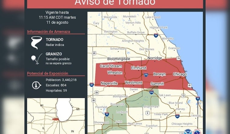
A tornado warning covering Chicago, Naperville, and Cicero went into effect Tuesday morning, expiring at 11:15 a.m. CDT, as a fast-moving line of storms packing wind gusts potentially exceeding 80 mph tore across the region. The alert, issued by the National Weather Service Chicago and based on radar indications of a tornado, put an estimated 3,440,218 people, 804 schools, and 59 hospitals inside its potential exposure zone.
Mayor Brandon Johnson amplified the warning to his followers, retweeting the National Weather Service Chicago alert from his account, according to a post shared by Mayor Brandon Johnson. The warning's coverage map stretched far beyond the city itself, listing communities including Naperville and Cicero alongside suburbs such as Wauconda, Mundelein, Lake Forest, Evanston, Schaumburg, Oak Lawn, and Joliet. The bulletin noted that hail was possible in size but not expected with this particular system.
A Storm Line Moving Fast, With Rain Rates Up to 3 Inches an Hour
The system behind Tuesday's warning was moving east at 48 to 55 mph, with the potential for wind gusts topping 80 mph and torrential rain falling at rates of 2 to 3 inches per hour, according to Desplaines Valley News. That kind of speed and intensity means straight-line winds alone can inflict damage comparable to an EF-0 tornado across a wide swath of the metro area, even without a confirmed touchdown.
Utility crews were already positioned ahead of the storm. ComEd prepositioned response crews and contractors across northern Illinois Tuesday, a step taken after prior summer storms this season caused localized power outages and left downed trees scattered across Chicago neighborhoods, per WTTW News. Saturated ground from previous rainfall raises the odds that high winds could uproot trees and take down distribution lines with them, the outlet reported.
When the National Weather Service issues a tornado warning covering Chicago, the city's Office of Emergency Management and Communications activates 112 outdoor warning sirens spread across 12 siren zones, sounding a three-minute rising-and-falling alert, according to the City of Chicago. Those same sirens are tested routinely on the first Tuesday of each month at 10 a.m., but during an actual emergency, they sound continuously for the full three minutes.
Third Round of Severe Weather in Days
Tuesday's warning arrived less than 48 hours after an August 9-10 storm complex brought heavy flooding, 50 mph wind gusts, more than 60 flight cancellations at O'Hare International Airport, and two confirmed EF-1 tornadoes in nearby LaSalle County, as reported by CBS News. Back-to-back systems like these compound urban drainage problems and stretch municipal crews thin, the station noted, as residents from one storm barely finish cleanup before the next moves in.
Whether Tuesday's storm actually produced a ground touchdown remained unclear as the warning window closed near 11:15 a.m., and it is not yet known how quickly ComEd and city forestry crews will be able to clear debris left over from the weekend's storms. How the OEMC's sirens and mobile alerts performed across the dense population zones in the warning's path is also an open question, per the same reporting.
A Season Already Defined by Repeated Outbreaks
This is not the first time in 2026 that Chicagoland has faced a multi-tornado event. A severe weather system on June 11 generated 13 confirmed tornadoes in the immediate Chicago area and 23 total across the NWS Chicago forecast region, causing severe structural damage in suburbs including roof destruction in Bridgeview, according to CBS News. Hoodline covered that outbreak as it unfolded in coverage of the June storm threat and in a separate report on a confirmed twister near Streator.
The broader numbers point to a pattern rather than an anomaly. Annual tornado totals across the NWS Chicago forecast region reached 58 in 2023 and 63 in 2024, well above the area's 10-to-20-year annual average of roughly 15 tornadoes, per FOX 32 Chicago. Part of that rise reflects better detection: improved high-resolution radar, social media video, and post-storm drone surveys now catch brief EF-0 tornadoes that once went unrecorded, the station reported.
Chicago has recorded 100 tornadoes within a 25-mile radius of the city since 1950, with July historically the most active month for twisters in the region, according to climatological data from VORTEX. Tornadoes are more frequent in the western collar counties, but they do occasionally track into urban Cook County, dispelling the notion that Lake Michigan or the city's skyscrapers offer any real protection.
Meteorological research attributes many of these summer outbreaks to what's known as a “Ring of Fire” atmospheric pattern, in which storm complexes travel along the edge of a summer heat dome, according to the National Weather Service. These setups frequently combine high straight-line winds with brief, embedded mesovortex tornadoes, a combination that produced the region's most extreme recent event: a July 15, 2024, derecho that set an all-time single-day record for the NWS Chicago forecast area with 32 confirmed tornadoes, some touching down within city limits, surpassing the prior record of 22 set in June 2014.
For financial scale, a Midwest derecho on August 10, 2020, produced 26 tornadoes across the region, including an EF-1 in Chicago's Rogers Park, and caused more than $11 billion in damage, making it the costliest thunderstorm event in modern U.S. history, per CBS News. Severe derecho-style storms, the outlet noted, can inflict power grid destruction on a scale comparable to a major hurricane landfall.





