

























































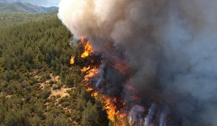
Two lightning-sparked wildfires burning on some of the most restricted land in the country have now scorched more than 51,000 acres northwest of Las Vegas, and the larger of the two blazes still has zero percent containment. The Mouse Meadow Fire has grown to roughly 38,000 acres inside the Nevada Test and Training Range and the Nevada National Security Site, while the smaller Quail Springs Fire in Lincoln County has burned 13,619 acres and is now 75 percent contained. Federal officials say no evacuations are in place and no publicly accessible structures or residences are threatened by either fire.
According to FOX5 Vegas, both fires were sparked by lightning in late July and are being jointly managed by the U.S. Air Force, the U.S. Department of Energy, and the U.S. Wildland Fire Service. The Great Basin Coordination Center said firefighters are improving indirect containment lines using existing roads while aerial surveillance crews look for safe openings to engage the flames directly. Wind and terrain continue to drive fire spread, and officials say extreme summer conditions - including above-normal temperatures, single-digit relative humidity, and poor overnight humidity recovery - are expected to keep challenging crews in the days ahead.
Two Fires, Two Very Different Trajectories
The Mouse Meadow Fire ignited about two weeks ago roughly 35 miles southwest of Rachel, on restricted federal land in Nye County, according to Current Wildfires. The fire has slowed on multiple fronts after running into natural barriers, open desert, and the scar left by the 2025 Gothic Fire, which burned 36,069 acres on the same test range in July 2025, as reported by Daily Dispatch. That earlier blaze was also sparked by lightning and managed under the same restricted-access rules.
Across the state line in Lincoln County, the Quail Springs Fire ignited the same day about 30 miles west of Alamo and has been far easier to corral. Firefighters reached 75 percent containment and have since demobilized most resources, according to the Las Vegas Review-Journal. An incident commander and a handful of engine crews remain on scene, patrolling the fire's perimeter and putting out remaining hotspots, while the fire itself shows only creeping and smoldering activity within its established containment lines.
Why Crews Are Fighting From the Air, Not the Ground
Neither fire is getting the kind of full ground-attack response typical of a civilian wildfire, and that's largely a function of geography. Department of Defense wildland fire management protocols bar direct ground suppression on the Nevada Test and Training Range whenever a fire threatens areas with potential unexploded ordnance, radiological materials, or other hazardous leftovers from decades of weapons testing, according to Nellis Air Force Base. The range itself is a 2.9-million-acre swath of ground managed by the U.S. Air Force Warfare Center at Nellis, which also controls another 5,000 square miles of restricted airspace - an area Nellis Air Force Base has described as larger than Delaware and Rhode Island combined.
Adjacent to the range sits the Nevada National Security Site, created in 1951 for Cold War-era nuclear weapons testing and spanning 1,375 square miles of access-controlled land in southeastern Nye County, according to the Nevada Division of Environmental Protection. The site remains strictly off-limits to the public. Given those restrictions, federal incident managers are prioritizing indirect containment lines along existing roads, aerial surveillance, and point protection rather than aggressive line construction near hazardous terrain, per the Bureau of Land Management.
A Brutal Nevada Fire Season
The fires are unfolding under a summer heat dome that has pushed relative humidity into the single digits across central Nevada, feeding rapid growth through pinyon-juniper timber, brush and fine desert grasses, according to Radar Watch HQ. Overnight humidity has recovered poorly, giving fire crews little relief once the sun goes down.
Fire managers have issued smoke advisories for the small town of Rachel and drawn up contingency plans for temporary closures of Nevada State Route 375 - the road known as the Extraterrestrial Highway - should conditions worsen, according to SierraDailyNews.com. Route 375 is the main thoroughfare serving Rachel and the surrounding Lincoln County ranchlands, and smoke from the fires may also drift into other parts of southern Nevada.
One of Five Major Fires Burning Across the State
Southern Nevada's outbreak is only part of a bigger picture. In central Nevada, the lightning-caused New Pass Fire had grown into the state's largest active wildfire of the 2026 season by early August, burning more than 31,600 acres northwest of Austin, according to the Las Vegas Review-Journal. Southern Nevada crews were also being pulled to help fight fires further north as the state juggled multiple large wildland incidents at once, the paper reported.
Despite the scale of Nevada's outbreak, nationwide wildfire activity has remained comparatively mild in 2026. Total burned acreage across the U.S. stood at roughly 2.5 million hectares through early August, a figure 53 to 56 percent below the two-decade national average, according to Current Wildfires and Copernicus wildfire tracking data.



