

























































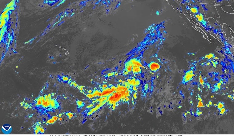
Forecasters are tracking two Pacific weather systems that could develop into tropical cyclones this week, with the closer one already showing a 90 percent chance of formation within the next seven days and the potential to threaten Hawaii as soon as this weekend. The system sits roughly 1,100 miles east-southeast of Hawaii Island, nearly stationary for now but expected to shift into a generally northwestward track across the Central Pacific. Showers and thunderstorms tied to the disturbance remain disorganized, but conditions are forecast to grow more favorable for development in the days ahead.
The closer system carries a 60 percent formation chance over the next two days, climbing to 90 percent within the week, according to the Honolulu Star-Advertiser. AccuWeather reported that the system could begin affecting Hawaii's weather as early as Friday and into the weekend, potentially bringing dangerous surf, heavy rain, flooding and damaging winds to parts of the islands. Even if it never organizes into a tropical cyclone, AccuWeather noted it is likely to bring dangerous surf and rip currents to the islands regardless. The Central Pacific Hurricane Center is urging the Hawaiian Islands to monitor the system's progress closely.
A Second System Trails Farther Out
A second disturbance is also on the Central Pacific Hurricane Center's radar, located well west-southwest of the Baja California peninsula and moving slowly northwest toward the Central Pacific. That system carries a 60 percent formation chance over the next week, according to the same CPHC outlook cited by the Star-Advertiser. CPHC forecasters expect a tropical depression or tropical storm to form from one of the two systems sometime in the middle portion of this week.
Long-range forecasts for Hawaii could shift dramatically if either system develops and tracks toward the islands, NWS forecasters caution. For now, the National Weather Service forecast for Honolulu calls for breezy trade winds and scattered showers this weekend, with high temperatures in the upper 80s. Whichever system reaches tropical storm strength first, meaning maximum sustained winds of 39 mph or greater, would need to strengthen further, to 74 mph sustained winds, before being classified a hurricane.
Why This Season Looks Different
Should either disturbance intensify into a fully formed tropical cyclone, it will be assigned the next name on the Central Pacific's rotating list: Lala, following recent storms like Hone and Iona. Central Pacific cyclones draw from four Hawaiian-language name lists maintained jointly by the Central Pacific Hurricane Center and the World Meteorological Organization, cycling continuously rather than resetting each year. The CPHC itself is co-located with the National Weather Service's Honolulu forecast office at the University of Hawaiʻi at Mānoa and tracks tropical activity across the Pacific between 140°W and 180° longitude, issuing advisories every six hours once a system is active.
This week's activity comes as NOAA's National Weather Service projects a 70 percent chance of an above-normal 2026 Central Pacific hurricane season, forecasting between 5 and 13 tropical cyclones amid returning moderate-to-strong El Niño conditions that reduce wind shear and allow storms to form and persist more easily. That marks a notable jump from 2025, when four tropical cyclones moved through or developed in the Central Pacific basin, in line with the 1991–2020 historical average of four to five storms per season. Hoodline's own review of Hawaii's quiet 2025 hurricane season found that year's systems, including Iona and Kiko, brought little statewide damage.
Storms Don't Need to Make Landfall to Cause Damage
Hawaii's hurricane history shows that proximity alone can be dangerous. Hurricane Iniki struck Kauai as a Category 4 storm on September 11, 1992, causing more than $3.1 billion in damage and seven direct deaths, and it remains the state's costliest and most destructive hurricane on record, according to the State of Hawaii Department of Defense. More recently, Hurricane Lane in August 2018 never made a direct landfall but still dumped a single-station peak of 57 inches of rain on Hawaii Island, making it the wettest tropical cyclone in Hawaii's history and the second-wettest in U.S. history behind Hurricane Harvey, per the National Weather Service.
A 2020 study by University of Hawaii meteorologists published in the Bulletin of the American Meteorological Society found that offshore hurricanes can simultaneously trigger severe interior rain flooding and leeward wildfires, as downslope winds around a storm's edges dry out vegetation even while its moist core dumps torrential rain elsewhere on the islands. The Central Pacific hurricane season runs officially from June 1 through November 30, with most tropical cyclogenesis occurring between July and October, the National Weather Service notes, though storms can occasionally form outside that window.
State Pushes 14-Day Supply Standard
The Hawaii Emergency Management Agency continues to advise residents to keep emergency kits stocked with at least 14 days of non-perishable food, one gallon of water per person per day, and essential medications, citing the vulnerability of the islands' maritime supply chains following severe storms. In May, the Hawaii Legislature enacted SB2109, a law requiring state emergency officials to build multilingual outreach campaigns and track statewide household compliance with that 14-day standard, with progress reports due to lawmakers through 2030, according to legislative records.
The current watch follows a string of close calls for Hawaii this summer. Hoodline previously reported on an easterly wave churning roughly 1,000 miles east-southeast of the islands with a 90 percent formation chance, and on Tropical Storm Fausto, which passed north of Hawaii in late July, shifting local trade winds and prompting high surf warnings. For now, forecasters say the islands' fate rests on how these two systems evolve in the coming days.





