

























































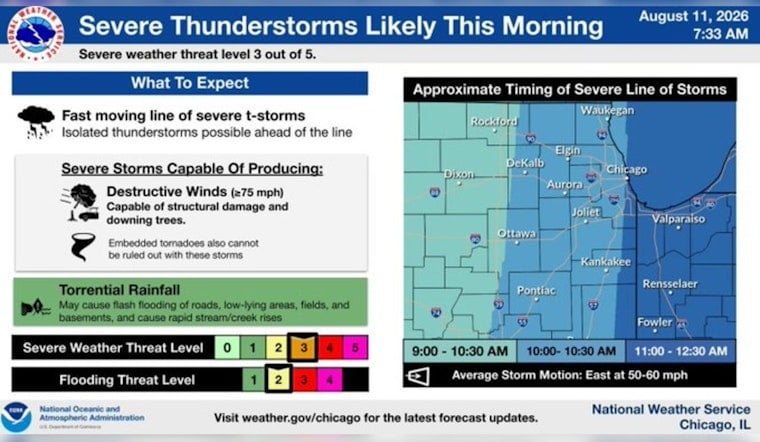
Chicago woke Tuesday to mostly clear skies and temperatures around 75 degrees, but the calm is not expected to last. A line or complex of thunderstorms could sweep across the city and surrounding region from late morning into early afternoon, bringing a serious risk of damaging wind, heavy rain and localized flooding.
Storms Could Hit Before Midafternoon
The National Weather Service says scattered storms could affect the area early Tuesday, with the more organized threat arriving roughly between 9 a.m. and 3 p.m. Storms may produce wind gusts as high as 80 mph, large hail and possibly a tornado, although the exact track and timing remain uncertain.
Tuesday’s high is expected near 79 degrees, with a 90% chance of showers and thunderstorms. Rainfall totals could reach three-quarters of an inch to 1 inch, while southeast winds of 5 to 15 mph may gust to 25 mph outside the strongest storms.
Heavy Rain Could Flood City Streets
Downpours could create localized flooding, particularly across Chicago’s urban core, where storm drains can struggle with a burst of rain. Forecasters are also watching locations that received several inches of rain Sunday and Monday, though no watches or warnings were listed for Illinois, Indiana or southern Lake Michigan in the latest forecast package.
Anyone heading out during the storm window should be ready for sudden visibility drops, strong crosswinds and water-covered roads. Never drive through flooded streets, and move indoors quickly if thunder is heard or severe weather alerts are issued.
More Storm Chances Follow
Storm coverage should ease after midafternoon, with only a slight chance of another shower or storm before 7 p.m. Tuesday night will turn partly cloudy, with a low near 70 degrees.
Wednesday and Thursday remain unsettled, with highs in the upper 70s and additional thunderstorm chances. Friday looks cooler and mostly dry near 74 degrees, but storm chances return Friday night and continue into a potentially stormy Saturday and Sunday, when highs rise back to around 79 and 81.





