

























































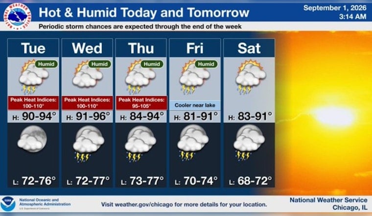
Chicago is waking up to a sticky Tuesday that will turn dangerous by afternoon, with temperatures headed into the low 90s and humidity making it feel much hotter. The city faces a heat advisory, a small but notable storm risk, and little relief before another hot day arrives Wednesday.
The National Weather Service Chicago has issued the heat advisory from noon to 9 p.m. Tuesday, warning that heat-index values could reach 100 to 110 degrees. Forecasters urge residents to drink plenty of fluids, stay in air conditioning when possible, avoid prolonged sun exposure, and check on relatives and neighbors who may be especially vulnerable.
Heat Builds Through The Afternoon
Mostly sunny skies will push Chicago to a high near 92 degrees, with the most oppressive conditions developing during the afternoon. Southwest winds of 5 to 10 mph will provide only limited relief as the combination of heat and humidity sends feels-like temperatures sharply higher.
There is a 20% chance of showers and thunderstorms, with the best opportunity from midmorning into early afternoon. The storm threat is considered low, but any thunderstorm that does develop could produce strong, potentially damaging wind gusts as it moves east.
Wednesday Stays Hot Before Storm Chances Rise
Wednesday looks even warmer, with a high near 93 and heat-index values as high as 101 under mostly sunny skies. The latest outlook is a substantive update from Monday’s forecast, when no heat advisory was posted; Hoodline’s earlier forecast had already flagged the midweek warm-up, but Tuesday’s advisory brings a sharper warning for outdoor plans.
A separate dense fog advisory remains in effect through 4 p.m. for the nearshore waters from Winthrop Harbor to Wilmette Harbor. Lakefront boaters and anyone heading onto the water should be prepared for reduced visibility, even as inland Chicago bakes.
Cooler, Stormier Pattern Arrives Thursday
Temperatures ease back to around 83 degrees Thursday and Friday, but scattered showers and thunderstorms become more likely. Friday’s storms are expected mainly before 1 p.m., followed by mostly sunny breaks.
The weekend brings a modest reset rather than an early taste of fall. Saturday should reach about 85 with a slight storm chance, Sunday settles near 83 with possible rain showers, and Labor Day trends cooler near 79 with a small chance of an early shower before mostly sunny skies take over.
For Tuesday, the safest plan is to limit strenuous outdoor activity during the afternoon, take frequent breaks in the shade or air conditioning, and keep water close. The heat advisory ends at 9 p.m., but the warm overnight low near 76 means Chicago will not cool down quickly.





