

























































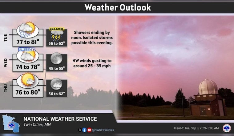
Minneapolis is starting Tuesday under a gray, unsettled sky, with showers and thunderstorms expected through the morning before the weather turns quieter. Temperatures near 66 degrees early will climb to around 81, making for a warm but muggy afternoon across the Twin Cities. The main concern for commuters is a burst of heavy rain before the morning rush fully clears.
The National Weather Service Twin Cities/Chanhassen says storms may produce periods of heavy rain, with roughly a quarter-inch to a half-inch possible in spots. Showers and thunderstorms are most likely before 11 a.m., followed by a smaller chance through noon as skies remain mostly cloudy.
Rain Should Fade Before The Afternoon Heat
Southwest winds will run around 10 to 15 mph Tuesday, while afternoon temperatures rise through the 70s. A few isolated storms could redevelop later in the day or evening, but forecasters say the severe-weather threat appears limited for the metro. No watches, warnings or advisories are listed for Minnesota or Wisconsin in the forecast.
Wednesday Brings The Week’s Best Weather
Wednesday looks like the cleanest day of the week, with sunny skies and a high near 78 degrees. West-northwest winds could gust as high as 30 mph, so patio umbrellas and lightweight lawn furniture may need a little supervision. Temperatures will fall to around 57 Wednesday night.
Thursday should stay sunny after areas of early-morning fog, with a high near 79 and light southwest winds. Friday turns warmer, reaching about 82 degrees, but rain showers and thunderstorms become possible from the morning into the evening, with wind gusts up to 35 mph.
Weekend Forecast Stays Changeable
Friday night brings the week’s strongest storm chance, with thunderstorms likely and a 60% chance of precipitation. Saturday should be mostly sunny after a slight chance of an early shower, with a high near 74, while Sunday looks cooler at around 68 degrees with another chance of showers and thunderstorms.
For Tuesday, drivers should allow extra time for slick roads and sudden visibility drops during heavier downpours. The wettest stretch should be over by late morning, but keeping an umbrella nearby will still be the sensible move before the clouds begin to break later in the week.





